
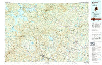
~ Rumford ME topo map, 1:100000 scale, 30 X 60 Minute, Historical, 1994, updated 1994
Rumford, Maine, USGS topographic map dated 1994.
Includes geographic coordinates (latitude and longitude). This topographic map is suitable for hiking, camping, and exploring, or framing it as a wall map.
Printed on-demand using high resolution imagery, on heavy weight and acid free paper, or alternatively on a variety of synthetic materials.
Topos available on paper, Waterproof, Poly, or Tyvek. Usually shipping rolled, unless combined with other folded maps in one order.
- Product Number: USGS-5685055
- Free digital map download (high-resolution, GeoPDF): Rumford, Maine (file size: 31 MB)
- Map Size: please refer to the dimensions of the GeoPDF map above
- Weight (paper map): ca. 55 grams
- Map Type: POD USGS Topographic Map
- Map Series: HTMC
- Map Verison: Historical
- Cell ID: 68268
- Scan ID: 460823
- Imprint Year: 1994
- Woodland Tint: Yes
- Aerial Photo Year: 1992
- Edit Year: 1994
- Datum: NAD27
- Map Projection: Universal Transverse Mercator
- Map published by United States Geological Survey
- Map Language: English
- Scanner Resolution: 600 dpi
- Map Cell Name: Rumford
- Grid size: 30 X 60 Minute
- Date on map: 1994
- Map Scale: 1:100000
- Geographical region: Maine, United States
Neighboring Maps:
All neighboring USGS topo maps are available for sale online at a variety of scales.
Spatial coverage:
Topo map Rumford, Maine, covers the geographical area associated the following places:
- Tainter Corner - New Sharon - Madrid - Oquossoc - Dallas - Dixfield Center - Dryden - Fairbanks - Temple Intervale - Riley - Coos Canyon - Redington - MacQuillis Corner - Peru - Mingo Springs - Jay - Farmington - Reeds - Pleasant Island - Upper Dam - West Peru - Rangeley - Mexico - Andover - Berry Mills - South Strong - Bald Mountain - Perham Junction - Allens Mills - Weld Corner - Wilton Intervale - Rumford Center - East Madrid - North Jay - New Portland - Byron - Weld - Barnjum - Strong - Knowltons Corner - Ridlonville - Stones Corner - South Rumford - Bullen Mills - Weeks Mills - North Newry - Hildreths Mill - Seaveys Corner - East New Portland - Farmington Falls - West Mills - South Rangeley - East Wilton - Ketchum - Chesterville - Phillips - Butterfield (historical) - Avon - Mooselookmeguntic - Ten Degree - Wilton - East Dixfield - Lexington - Beans Corner - South Arm - Temple - Soule Mill - North New Portland - Roxbury - Overlake - Macy - Bemis - West Farmington - Houghton - Mountainview - Kingfield - Rumford Point - Middle Dam - New Vineyard - East Andover - Salem - Rumford - Hale - Chase Corner - Carthage - South Andover - North Chesterville - Goodrich Corner - Dixfield - Frye - Madrid Junction - Virginia - Smith Crossing - Avon Corner
- Map Area ID: AREA4544.5-71-70
- Northwest corner Lat/Long code: USGSNW45-71
- Northeast corner Lat/Long code: USGSNE45-70
- Southwest corner Lat/Long code: USGSSW44.5-71
- Southeast corner Lat/Long code: USGSSE44.5-70
- Northern map edge Latitude: 45
- Southern map edge Latitude: 44.5
- Western map edge Longitude: -71
- Eastern map edge Longitude: -70


