
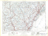
~ Portland ME topo map, 1:250000 scale, 1 X 2 Degree, Historical, 1963, updated 1963
Portland, Maine, USGS topographic map dated 1963.
Includes geographic coordinates (latitude and longitude). This topographic map is suitable for hiking, camping, and exploring, or framing it as a wall map.
Printed on-demand using high resolution imagery, on heavy weight and acid free paper, or alternatively on a variety of synthetic materials.
Topos available on paper, Waterproof, Poly, or Tyvek. Usually shipping rolled, unless combined with other folded maps in one order.
- Product Number: USGS-5684963
- Free digital map download (high-resolution, GeoPDF): Portland, Maine (file size: 16 MB)
- Map Size: please refer to the dimensions of the GeoPDF map above
- Weight (paper map): ca. 55 grams
- Map Type: POD USGS Topographic Map
- Map Series: HTMC
- Map Verison: Historical
- Cell ID: 68970
- Scan ID: 461064
- Imprint Year: 1963
- Visual Version Number: 2
- Field Check Year: 1956
- Datum: Unstated
- Map Projection: Transverse Mercator
- Map published by United States Army Corps of Engineers
- Map published by United States Army
- Map Language: English
- Scanner Resolution: 600 dpi
- Map Cell Name: Portland
- Grid size: 1 X 2 Degree
- Date on map: 1963
- Map Scale: 1:250000
- Geographical region: Maine, United States
Neighboring Maps:
All neighboring USGS topo maps are available for sale online at a variety of scales.
Spatial coverage:
Topo map Portland, Maine, covers the geographical area associated the following places:
- West Henniker Emerson Station - Antrim - Greenland Station - Clay Hill - Wells Beach - Salisbury - Hills Corner - Kelwyn Park - Agamenticus Station - Wolfeboro Center - Colby - Garrison Hills Estates - Pleasant Hill - East Lebanon - Chicopee - Cutts Island - East Springfield - Emerys Corner - North Wolfeboro - East Andover - Upper Landing - Plymouth - West Durham - Ossipee Mills - Atlantic Heights - Rockywold - North Gorham - Sanbornton - Onway Lake - Meadowbrook - Hooksett - Campton Lower Village - Ossipee Valley - Effingham Falls - West Rye - Walnut Hill - Emory Corner - Denmark - Hillsboro Upper Village - West Thornton - Buffum Hill - Sebago Center - Sunset Landing - Pine Point Beach - Gossville - Pequawket - Chickville - Douglas Hill - Hillsboro Center - South Windham - Gerrish Corner - Winnipesaukee - Waterville Valley - Strafford Corner - York Landing - Chicks Corner - Dow Corner - North Nottingham - Kennebunk - Airport Village - Mount Major - South Effingham - West Hopkinton - West Lebanon - Concord Manor - Cumberland Mills - Wolfeboro - Gorham - Deerfield - Sprague City - Miller Corner - Merrill Corners - Woodlands - Crams Corner - West Scarborough - Webster Lake - East Grafton - East Brownfield - East Concord - North Dorchester - Roberts Corner - South Alexandria - North Waterboro - Hatfield Corner - Porter - Meeting House Hill - Lake Arrowhead Estates - Stanwood Park - West Cumberland - Horse Corner - Estes Hill - South Casco - Rankins Mill - Kennard Corner - Lower Village - Albany - Severance - Alexandria - West Brownfield - Lake Shore Park
- Map Area ID: AREA4443-72-70
- Northwest corner Lat/Long code: USGSNW44-72
- Northeast corner Lat/Long code: USGSNE44-70
- Southwest corner Lat/Long code: USGSSW43-72
- Southeast corner Lat/Long code: USGSSE43-70
- Northern map edge Latitude: 44
- Southern map edge Latitude: 43
- Western map edge Longitude: -72
- Eastern map edge Longitude: -70


