
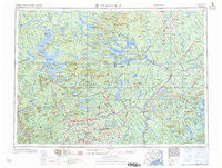
~ Millinocket ME topo map, 1:250000 scale, 1 X 2 Degree, Historical, 1960, updated 1960
Millinocket, Maine, USGS topographic map dated 1960.
Includes geographic coordinates (latitude and longitude). This topographic map is suitable for hiking, camping, and exploring, or framing it as a wall map.
Printed on-demand using high resolution imagery, on heavy weight and acid free paper, or alternatively on a variety of synthetic materials.
Topos available on paper, Waterproof, Poly, or Tyvek. Usually shipping rolled, unless combined with other folded maps in one order.
- Product Number: USGS-5684641
- Free digital map download (high-resolution, GeoPDF): Millinocket, Maine (file size: 25 MB)
- Map Size: please refer to the dimensions of the GeoPDF map above
- Weight (paper map): ca. 55 grams
- Map Type: POD USGS Topographic Map
- Map Series: HTMC
- Map Verison: Historical
- Cell ID: 75021
- Scan ID: 460608
- Imprint Year: 1960
- Woodland Tint: Yes
- Visual Version Number: 1
- Field Check Year: 1954
- Datum: Unstated
- Map Projection: Transverse Mercator
- Map published by United States Army Corps of Engineers
- Map published by United States Army
- Map Language: English
- Scanner Resolution: 600 dpi
- Map Cell Name: Millinocket
- Grid size: 1 X 2 Degree
- Date on map: 1960
- Map Scale: 1:250000
- Geographical region: Maine, United States
Neighboring Maps:
All neighboring USGS topo maps are available for sale online at a variety of scales.
Spatial coverage:
Topo map Millinocket, Maine, covers the geographical area associated the following places:
- Caratunk - Oak Park Manor - Upper Abbot - Burlington - Gantners Landing - West Dover - Greenfield - Tarratine - Cardville - Gerry - Mattawamkeag - Prairie - North East Carry - Preble Corner - Poplar Ripps - Hudson - Pea Ridge - Libby Corner - Brassua - West Charleston - Parson Landing - East Winn - Sherman Mills - Gilford - Webb Hill - Lake Moxie - Storers Corner - Prentiss - Atkinson Mills - Back Settlement - West Enfield - Lee - Oliver Hill Corner - West Seboeis - East Dover - Lagrange - East Corinth - Moody Corner - Howland - Seboeis - Stacyville - Howard Corner - Brownville Junction - Durbin Corner - Bradford - Enfield - Onawa - Sebec Corners - Macwahoc - Benedicta - Starbirds - Charleston - Alton - Bancroft - Bowerbank - Monson - Barnard - Bingham - East Lowell - Benson - Burdin Corner - Brighton - Happy Corner - Bowden (historical) - Willimantic - Johnson Corner - Patten - Milo - South Dover - Cole Corner - Deadwater - Moscow - Lake View - Monson Junction - Medford - Perkins - Sherman Station - Derby - Lincoln Center - Hicks Corner - Sebec Lake - Spooners Mill - Shirley Mills - Bodfish - Bowerbank (historical) - Dexter - Lower Shirley Corner - Crockertown - Saponac - Reed - Earley Landing - Pingree Center - Hay Brook - Boyd Lake - Lowell - Carr Corner - Kokadjo - Davidson (historical) - North Guilford - Upper Shirley Corner
- Map Area ID: AREA4645-70-68
- Northwest corner Lat/Long code: USGSNW46-70
- Northeast corner Lat/Long code: USGSNE46-68
- Southwest corner Lat/Long code: USGSSW45-70
- Southeast corner Lat/Long code: USGSSE45-68
- Northern map edge Latitude: 46
- Southern map edge Latitude: 45
- Western map edge Longitude: -70
- Eastern map edge Longitude: -68


