
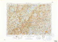
~ Lewiston ME topo map, 1:250000 scale, 1 X 2 Degree, Historical, 1961, updated 1961
Lewiston, Maine, USGS topographic map dated 1961.
Includes geographic coordinates (latitude and longitude). This topographic map is suitable for hiking, camping, and exploring, or framing it as a wall map.
Printed on-demand using high resolution imagery, on heavy weight and acid free paper, or alternatively on a variety of synthetic materials.
Topos available on paper, Waterproof, Poly, or Tyvek. Usually shipping rolled, unless combined with other folded maps in one order.
- Product Number: USGS-5684525
- Free digital map download (high-resolution, GeoPDF): Lewiston, Maine (file size: 29 MB)
- Map Size: please refer to the dimensions of the GeoPDF map above
- Weight (paper map): ca. 55 grams
- Map Type: POD USGS Topographic Map
- Map Series: HTMC
- Map Verison: Historical
- Cell ID: 75018
- Scan ID: 460549
- Imprint Year: 1961
- Woodland Tint: Yes
- Visual Version Number: 1
- Field Check Year: 1956
- Datum: Unstated
- Map Projection: Transverse Mercator
- Map published by United States Army Corps of Engineers
- Map published by United States Army
- Map Language: English
- Scanner Resolution: 600 dpi
- Map Cell Name: Lewiston
- Grid size: 1 X 2 Degree
- Date on map: 1961
- Map Scale: 1:250000
- Geographical region: Maine, United States
Neighboring Maps:
All neighboring USGS topo maps are available for sale online at a variety of scales.
Spatial coverage:
Topo map Lewiston, Maine, covers the geographical area associated the following places:
- Minot - Nobles Corner - Landaff Center - Hartford - Stevens Mill - Goodrich Falls - Mountain Lakes - Lovell - Maplewood - Toneys Mobile Park - East Lyndon - Moussam - Welchville - Sanderson Corners - Panno Place - West Waterford - East Wilton - Scott - Harrison - Lewiston - West Minot - Guildhall - West Paris - West Bethel - South Leeds - Livermore Center - Middle Dam - Bretton Woods - Island Pond - Chatham - Center Haverhill - Chambers Corner - North New Portland - East Milton - Knowltons Corner - Oxford Station - Roxbury - Hunts Corner - Savageville - West Bath - Randolph Hill - Middle Intervale - Pratt Corner - Ireland - Chase Corner - Coos Canyon - Dryden - Danville - Murphy Corner - Cooks Crossing - Texas - South Paris - Fryeburg - Marshfield Station - East Wales - Bald Mountain - Ralston Corner - Norway Lake - Boutin Corner - Lewiston Junction - Tinkerville - Scribners Mill - West Mills - Black Mountain Cabin - East Stoneham - Browns Mill - East Otisfield - Hildreths Mill - North Chesterville - Maidstone - Monmouth - Sawyers River - Apthorp - New Sharon - East Sweden - Worthley Pond - Empire - East Bethel - Butterfield (historical) - Sprague Mill - Ten Degree - East Peru - Center Lovell - West Sumner - Five Corners - Keenes Corner - South Poland - South Rumford - Kingfield - Sodom - Ridlonville - Frye - MacQuillis Corner - Lisbon Center - Livermore - West Stewartstown - Rowe Corner - West Leeds - Danville Corner - Beatties
- Map Area ID: AREA4544-72-70
- Northwest corner Lat/Long code: USGSNW45-72
- Northeast corner Lat/Long code: USGSNE45-70
- Southwest corner Lat/Long code: USGSSW44-72
- Southeast corner Lat/Long code: USGSSE44-70
- Northern map edge Latitude: 45
- Southern map edge Latitude: 44
- Western map edge Longitude: -72
- Eastern map edge Longitude: -70


