
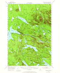
~ Harrington Lake ME topo map, 1:62500 scale, 15 X 15 Minute, Historical, 1954, updated 1965
Harrington Lake, Maine, USGS topographic map dated 1954.
Includes geographic coordinates (latitude and longitude). This topographic map is suitable for hiking, camping, and exploring, or framing it as a wall map.
Printed on-demand using high resolution imagery, on heavy weight and acid free paper, or alternatively on a variety of synthetic materials.
Topos available on paper, Waterproof, Poly, or Tyvek. Usually shipping rolled, unless combined with other folded maps in one order.
- Product Number: USGS-5684381
- Free digital map download (high-resolution, GeoPDF): Harrington Lake, Maine (file size: 9 MB)
- Map Size: please refer to the dimensions of the GeoPDF map above
- Weight (paper map): ca. 55 grams
- Map Type: POD USGS Topographic Map
- Map Series: HTMC
- Map Verison: Historical
- Cell ID: 55086
- Scan ID: 460477
- Imprint Year: 1965
- Woodland Tint: Yes
- Aerial Photo Year: 1954
- Field Check Year: 1954
- Datum: NAD27
- Map Projection: Polyconic
- Map published by United States Geological Survey
- Map Language: English
- Scanner Resolution: 600 dpi
- Map Cell Name: Harrington Lake
- Grid size: 15 X 15 Minute
- Date on map: 1954
- Map Scale: 1:62500
- Geographical region: Maine, United States
Neighboring Maps:
All neighboring USGS topo maps are available for sale online at a variety of scales.
Spatial coverage:
Topo map Harrington Lake, Maine, covers the geographical area associated the following places:
- Bean Brook - Gulliver Brook - Big Niagara Falls - Duck Brook - Pollywog Pond - Ripogenus Lake - Fourth Debsconeag Lake - Windy Pitch - Little Beaver Pond - Duck Pond - Stink Pond - Soubunge Mountain - Kelly Pond - Allagash Gateway Campsite - Frost Pond - Chesuncook Dam - Lost Pond - Jackson Pond - Polly Pond - Clifford Pond - Lily Pad Pond - Soper Brook - Gould Pond - Bean Pond - Brighton Deadwater - Rainbow Lake Dam - Rainbow Lake - Little Beaver Pond - Beaver Pond - Pitman Pond - Nesowadnehunk Stream - Sixth Debsconeag Pond - Egg Pond - Sewall Pond - T3 R10 WELS - Fowler Pond - T2 R10 WELS - Grassy Pond - Moose Bosom - Little Minister Pond - West Peak - Chesuncook-Ripogenus Lake - Daicey Pond - Jackson Pond - Little Rocky Pond - Collins Pond - Harrington Lake - Tracy Pond - Seventh Debsconeag Pond - Nahmakanta Lake - T3 R11 WELS - Holbrook Pond - Horserace - Ledge Falls - Rainbow Township - Horserace Ponds - Carry Pond - Nesowadnehunk Falls - Ripogenus Dam - Slide Dam - Little Niagara Falls - Chesuncook Stream - Bear Pond - Nesowaonehunk Field - Rocky Pond - South Brother - Slaughter Brook - Sandy Stream - Sentinel Mountain - Roaring Brook - Ripogenus Gorge - Slaughter Pond - Indian Pitch Ponds - Harrington Pond - Little Nesowadnehunk Stream - Unorganized Territory of Northeast Piscataquis - Big Eddy - Big Minister Pond - Stratton Pond - Little Frost Pond - Woodman Pond - Little Hurd Pond - Kidney Pond - Stratton Brook - Mount Coe - Bean Hole Mountain - Little Kelly Pond - T4 R11 WELS - Williams Pond - Bean Ponds - Mount Veto - Big Beaver Pond - Frost Pond Campground - Blue Trail - Little Mud Pond - McKenna Pond - Third Debsconeag Lake - Horserace Brook - Gould Brook - Draper Pond
- Map Area ID: AREA4645.75-69.25-69
- Northwest corner Lat/Long code: USGSNW46-69.25
- Northeast corner Lat/Long code: USGSNE46-69
- Southwest corner Lat/Long code: USGSSW45.75-69.25
- Southeast corner Lat/Long code: USGSSE45.75-69
- Northern map edge Latitude: 46
- Southern map edge Latitude: 45.75
- Western map edge Longitude: -69.25
- Eastern map edge Longitude: -69


