
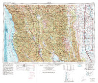
~ Ukiah CA topo map, 1:250000 scale, 1 X 2 Degree, Historical, 1957, updated 1980
Ukiah, California, USGS topographic map dated 1957.
Includes geographic coordinates (latitude and longitude). This topographic map is suitable for hiking, camping, and exploring, or framing it as a wall map.
Printed on-demand using high resolution imagery, on heavy weight and acid free paper, or alternatively on a variety of synthetic materials.
Topos available on paper, Waterproof, Poly, or Tyvek. Usually shipping rolled, unless combined with other folded maps in one order.
- Product Number: USGS-5683237
- Free digital map download (high-resolution, GeoPDF): Ukiah, California (file size: 27 MB)
- Map Size: please refer to the dimensions of the GeoPDF map above
- Weight (paper map): ca. 55 grams
- Map Type: POD USGS Topographic Map
- Map Series: HTMC
- Map Verison: Historical
- Cell ID: 69070
- Scan ID: 302181
- Imprint Year: 1980
- Woodland Tint: Yes
- Aerial Photo Year: 1952
- Edit Year: 1971
- Field Check Year: 1957
- Datum: Unstated
- Map Projection: Transverse Mercator
- Map published by United States Geological Survey
- Map published by United States Department of Commerce
- Keywords: Overedge with No Adjacent Map
- Map Language: English
- Scanner Resolution: 600 dpi
- Map Cell Name: Ukiah
- Grid size: 1 X 2 Degree
- Date on map: 1957
- Map Scale: 1:250000
- Geographical region: California, United States
Neighboring Maps:
All neighboring USGS topo maps are available for sale online at a variety of scales.
Spatial coverage:
Topo map Ukiah, California, covers the geographical area associated the following places:
- Mitchell Place - Navarro - Presswood - Delevan - Wild Bill Place - Little River - Comptche - Talmage - Squaw Hill - Devils Elbow - Delphos - Heeser Addition - Wanhala - Rotavele - Fouts Springs - Ensign (historical) - Hough Springs - Lucerne - Bell Springs - Melbourne - Ukiah Rancheria - Crowley - Indian Springs - Shake City - Clear Lake Keys - Asylum - Boonville - Flournoy - Bollinger Place - Cummings - Mendocino - Malton (historical) - Prize (historical) - Newport - Wagon Wheel Mobile Home Park - Mills Orchards - Kibesillah - Albion - Genevra - Alpine - Piercy - Largo - Wilbur Springs - Old Bailey Place - Clare Mill - Orrs Springs - Soda Springs - Sherburns (historical) - Ideal Mobile Home Park - Lodoga - Griffin Place - Northspur - Potter Valley - Willits - Cleone - Kurand (historical) - Ralph Leggett Place - Howard Mill (historical) - Cortena - Cape Horn - Sylvandale (historical) - Orland - Tan Oak Park - Greenwood - Valley Oaks Mobile Home Park - Philbrick Mill - Maxwell - Copeland - Laytonville - Meadowood Estates - Copper City - Regina Heights - Mills Orchard - Pellow Place - Delmonico Place - Nice - Sites - Soda Bay - Williams - Witter Springs (historical) - Grove - Glenhaven - Dawson Place - Jenks Place - Grapit - Cory - Bluegum - Bredehoft Place - Lane Redwood Flat (historical) - Ramsey - Fort Bragg - Steuben Place - Ridgewood Park - Bonnie View - Hardy - Rockport - College City - Dogtown - Whiskey Springs - Reilly Heights
- Map Area ID: AREA4039-124-122
- Northwest corner Lat/Long code: USGSNW40-124
- Northeast corner Lat/Long code: USGSNE40-122
- Southwest corner Lat/Long code: USGSSW39-124
- Southeast corner Lat/Long code: USGSSE39-122
- Northern map edge Latitude: 40
- Southern map edge Latitude: 39
- Western map edge Longitude: -124
- Eastern map edge Longitude: -122


