
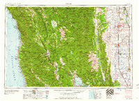
~ Ukiah CA topo map, 1:250000 scale, 1 X 2 Degree, Historical, 1960
Ukiah, California, USGS topographic map dated 1960.
Includes geographic coordinates (latitude and longitude). This topographic map is suitable for hiking, camping, and exploring, or framing it as a wall map.
Printed on-demand using high resolution imagery, on heavy weight and acid free paper, or alternatively on a variety of synthetic materials.
Topos available on paper, Waterproof, Poly, or Tyvek. Usually shipping rolled, unless combined with other folded maps in one order.
- Product Number: USGS-5683231
- Free digital map download (high-resolution, GeoPDF): Ukiah, California (file size: 22 MB)
- Map Size: please refer to the dimensions of the GeoPDF map above
- Weight (paper map): ca. 55 grams
- Map Type: POD USGS Topographic Map
- Map Series: HTMC
- Map Verison: Historical
- Cell ID: 69070
- Scan ID: 302178
- Woodland Tint: Yes
- Field Check Year: 1957
- Datum: Unstated
- Map Projection: Transverse Mercator
- Map published by United States Army Corps of Engineers
- Map published by United States Army
- Keywords: Overedge with No Adjacent Map
- Map Language: English
- Scanner Resolution: 600 dpi
- Map Cell Name: Ukiah
- Grid size: 1 X 2 Degree
- Date on map: 1960
- Map Scale: 1:250000
- Geographical region: California, United States
Neighboring Maps:
All neighboring USGS topo maps are available for sale online at a variety of scales.
Spatial coverage:
Topo map Ukiah, California, covers the geographical area associated the following places:
- Rose Place - Kirkwood - Union Landing - Bartlett Springs - Elk - Soda Bay - Richfield - South Fork - Wagon Wheel Mobile Home Park - Ralph Leggett Place - Longvale - Delmonico Place - Millsholm (historical) - Clear Lake Keys - Alpine - Rowes (historical) - Noyo - Griffin Place - Brooktrails - Fiddlers Green - Caspar - Largo - Dunlap (historical) - Lyman (historical) - Hays Place - Ensign (historical) - Willow Glenn Mobile Home Park - Glenblair - Covelo - Whitesboro - Sherburns (historical) - Philbrick Mill - Barkerville (historical) - Jacinto - Pellow Place - Jenks Place - Sylvandale (historical) - Cooper - Philo - Eastlake (historical) - Bell Springs - Reyes Place - Lodoga - Ridgewood Park - Willits - Lurline (historical) - Four Pines - Laytonville - Irmulco - Dos Rios - Greenwood - Wilbur Springs - Elk Creek - Lucerne - Potter Valley - Mendocino - Pratt Place - Maxwell - Melbourne - Cameron - Vann - Crocker Place - Heath Place - Hendy Grove - Talmage - Soda Springs - Inglenook - Pole Garden - Coyote Valley Rancheria (historical) - Laughlin - Logandale - Pomo - Soda Springs - Malton (historical) - Corning - Dawson Place - Underwood Park - Jim Leggett Place - Presswood - Carpenter Place - Hales Grove - Three Crossing - College City - Reynolds Place (historical) - Shake City - Prize (historical) - Mills Orchard - Clearlake Oaks - Valley Oaks Mobile Home Park - Vichy Springs - Wanhala - Sites - Stonyford - Genevra - Howard Mill (historical) - Farley - Houghton Place - Indian Springs - Mills Orchards - Piercy
- Map Area ID: AREA4039-124-122
- Northwest corner Lat/Long code: USGSNW40-124
- Northeast corner Lat/Long code: USGSNE40-122
- Southwest corner Lat/Long code: USGSSW39-124
- Southeast corner Lat/Long code: USGSSE39-122
- Northern map edge Latitude: 40
- Southern map edge Latitude: 39
- Western map edge Longitude: -124
- Eastern map edge Longitude: -122


