
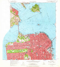
~ San Francisco North CA topo map, 1:24000 scale, 7.5 X 7.5 Minute, Historical, 1956, updated 1964
San Francisco North, California, USGS topographic map dated 1956.
Includes geographic coordinates (latitude and longitude). This topographic map is suitable for hiking, camping, and exploring, or framing it as a wall map.
Printed on-demand using high resolution imagery, on heavy weight and acid free paper, or alternatively on a variety of synthetic materials.
Topos available on paper, Waterproof, Poly, or Tyvek. Usually shipping rolled, unless combined with other folded maps in one order.
- Product Number: USGS-5683079
- Free digital map download (high-resolution, GeoPDF): San Francisco North, California (file size: 13 MB)
- Map Size: please refer to the dimensions of the GeoPDF map above
- Weight (paper map): ca. 55 grams
- Map Type: POD USGS Topographic Map
- Map Series: HTMC
- Map Verison: Historical
- Cell ID: 39619
- Scan ID: 300062
- Imprint Year: 1964
- Woodland Tint: Yes
- Aerial Photo Year: 1956
- Field Check Year: 1956
- Datum: NAD27
- Map Projection: Polyconic
- Map published by United States Geological Survey
- Keywords: Overedge
- Map Language: English
- Scanner Resolution: 600 dpi
- Map Cell Name: San Francisco North
- Grid size: 7.5 X 7.5 Minute
- Date on map: 1956
- Map Scale: 1:24000
- Geographical region: California, United States
Neighboring Maps:
All neighboring USGS topo maps are available for sale online at a variety of scales.
Spatial coverage:
Topo map San Francisco North, California, covers the geographical area associated the following places:
- Saint Francis Square - San Francisco - Forest Knolls - Laguna Heights - Thomas Paine Square - Fort McDowell - Marcus Garvey Square - Malcolm X Square - Frederick Douglass Haynes Gardens - Presidio Terrace - Sunset District - Tiburon - Martin Luther King Square - North Beach - Park View Commons - Bayside Village - Fort Winfield Scott - Marina District - Opera Plaza - Banneker Homes - Doelger City - Pacific Heights - Seacliff - Sydney Town (historical) - Western Addition - Sausalito - Victoria Mews - Little Osaka - Loren Miller Homes - Amanico Ergina Village - Jordan Park - Richmond District - Friendship Village - Potrero District - Haight-Ashbury - Chinatown - North Point Public Housing - Mission District - Belvedere - Little Italy - Golden Gate Heights - Valencia Gardens
- Map Area ID: AREA37.87537.75-122.5-122.375
- Northwest corner Lat/Long code: USGSNW37.875-122.5
- Northeast corner Lat/Long code: USGSNE37.875-122.375
- Southwest corner Lat/Long code: USGSSW37.75-122.5
- Southeast corner Lat/Long code: USGSSE37.75-122.375
- Northern map edge Latitude: 37.875
- Southern map edge Latitude: 37.75
- Western map edge Longitude: -122.5
- Eastern map edge Longitude: -122.375


