
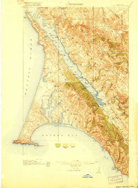
~ Point Reyes CA topo map, 1:62500 scale, 15 X 15 Minute, Historical, 1918
Point Reyes, California, USGS topographic map dated 1918.
Includes geographic coordinates (latitude and longitude). This topographic map is suitable for hiking, camping, and exploring, or framing it as a wall map.
Printed on-demand using high resolution imagery, on heavy weight and acid free paper, or alternatively on a variety of synthetic materials.
Topos available on paper, Waterproof, Poly, or Tyvek. Usually shipping rolled, unless combined with other folded maps in one order.
- Product Number: USGS-5683019
- Free digital map download (high-resolution, GeoPDF): Point Reyes, California (file size: 12 MB)
- Map Size: please refer to the dimensions of the GeoPDF map above
- Weight (paper map): ca. 55 grams
- Map Type: POD USGS Topographic Map
- Map Series: HTMC
- Map Verison: Historical
- Cell ID: 61119
- Scan ID: 298609
- Woodland Tint: Yes
- Survey Year: 1916
- Datum: Unstated
- Map Projection: Unstated
- Map published by United States Geological Survey
- Keywords: Overedge with No Adjacent Map
- Map Language: English
- Scanner Resolution: 600 dpi
- Map Cell Name: Point Reyes
- Grid size: 15 X 15 Minute
- Date on map: 1918
- Map Scale: 1:62500
- Geographical region: California, United States
Neighboring Maps:
All neighboring USGS topo maps are available for sale online at a variety of scales.
Spatial coverage:
Topo map Point Reyes, California, covers the geographical area associated the following places:
- Point Reyes Station - Five Brooks - Cypress Grove - Seahaven - Point Reyes (historical) - Olema - Reynolds - Vincent Landing - Tocaloma - Nicks Cove - Lairds Landing - Bivalve - Blakes Landing - Ocean Roar - McDonald - Sacramento Landing - Inverness Park - Millerton - Inverness - Marshall - Tomales - Marconi - Hamlet
- Map Area ID: AREA38.2538-123-122.75
- Northwest corner Lat/Long code: USGSNW38.25-123
- Northeast corner Lat/Long code: USGSNE38.25-122.75
- Southwest corner Lat/Long code: USGSSW38-123
- Southeast corner Lat/Long code: USGSSE38-122.75
- Northern map edge Latitude: 38.25
- Southern map edge Latitude: 38
- Western map edge Longitude: -123
- Eastern map edge Longitude: -122.75


