
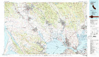
~ Napa CA topo map, 1:100000 scale, 30 X 60 Minute, Historical, 1983, updated 1983
Napa, California, USGS topographic map dated 1983.
Includes geographic coordinates (latitude and longitude). This topographic map is suitable for hiking, camping, and exploring, or framing it as a wall map.
Printed on-demand using high resolution imagery, on heavy weight and acid free paper, or alternatively on a variety of synthetic materials.
Topos available on paper, Waterproof, Poly, or Tyvek. Usually shipping rolled, unless combined with other folded maps in one order.
- Product Number: USGS-5682935
- Free digital map download (high-resolution, GeoPDF): Napa, California (file size: 31 MB)
- Map Size: please refer to the dimensions of the GeoPDF map above
- Weight (paper map): ca. 55 grams
- Map Type: POD USGS Topographic Map
- Map Series: HTMC
- Map Verison: Historical
- Cell ID: 68027
- Scan ID: 299125
- Imprint Year: 1983
- Woodland Tint: Yes
- Aerial Photo Year: 1979
- Edit Year: 1983
- Datum: NAD27
- Map Projection: Universal Transverse Mercator
- Map published by United States Geological Survey
- Keywords: Overedge
- Map Language: English
- Scanner Resolution: 600 dpi
- Map Cell Name: Napa
- Grid size: 30 X 60 Minute
- Date on map: 1983
- Map Scale: 1:100000
- Geographical region: California, United States
Neighboring Maps:
All neighboring USGS topo maps are available for sale online at a variety of scales.
Spatial coverage:
Topo map Napa, California, covers the geographical area associated the following places:
- Squab - Gateley - Mailliard (historical) - Woodacre - Suisun - Buchli - South Vallejo - Bel Marin Keys - Seahaven - Northwood Lodge - Tolenas - Rockville - East Petaluma - Yountville - Rafael Village - Oakville - Schellville - Bayo Vista - Zinfandel - Lucas Valley - Occidental - Agua Caliente - Roseland - Sears Point - Imola - McNear - Hamlet - Two Rock - Greenwood (historical) - Vincent Landing - Benicia - Dewitt - Avon - Marshall - Cypress Grove - Hessel - Suscol - Bucktown - Inverness - Alten - Bellevue - Montgomery Village - Salvador - Buena Vista - Oak Knoll - McGill - Ely (historical) - Rose (historical) - South Santa Rosa - Batto - Rohnert Park - Verano - Chabot Terrace - Clyde - Monsanto - Collins - Mankas Corner - Lagunitas - Roblar - Nicasio - Santa Nella - Bloomfield - Bayview - Merazo - Pueblo Serena Mobile Home Park - Marconi - Sonoma - Riccas Corner - Sleepy Hollow - Carquinez Heights - Tormey - Saint Vincent - Felice (historical) - Pinole - Pierce - Wingo - American Canyon - Sebastopol - Hopyard (historical) - Nicks Cove - Boyes Hot Springs - Gravenstein - Noel Heights - Mills - Flosden Acres - Lakeville - Freestone - Barlow - McDonald - Woolsey - Fairfield - Haystack - Shafter - Vine Hill - Union - Point Reyes (historical) - Atlas - Sacramento Landing - Manzana - Marinwood
- Map Area ID: AREA38.538-123-122
- Northwest corner Lat/Long code: USGSNW38.5-123
- Northeast corner Lat/Long code: USGSNE38.5-122
- Southwest corner Lat/Long code: USGSSW38-123
- Southeast corner Lat/Long code: USGSSE38-122
- Northern map edge Latitude: 38.5
- Southern map edge Latitude: 38
- Western map edge Longitude: -123
- Eastern map edge Longitude: -122


