
~ Breton Sound LA topo map, 1:250000 scale, 1 X 2 Degree, Historical, 1957, updated 1974
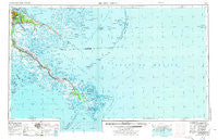
Breton Sound, Louisiana, USGS topographic map dated 1957.
Includes geographic coordinates (latitude and longitude). This topographic map is suitable for hiking, camping, and exploring, or framing it as a wall map.
Printed on-demand using high resolution imagery, on heavy weight and acid free paper, or alternatively on a variety of synthetic materials.
Topos available on paper, Waterproof, Poly, or Tyvek. Usually shipping rolled, unless combined with other folded maps in one order.
- Product Number: USGS-5680591
- Free digital map download (high-resolution, GeoPDF): Breton Sound, Louisiana (file size: 21 MB)
- Map Size: please refer to the dimensions of the GeoPDF map above
- Weight (paper map): ca. 55 grams
- Map Type: POD USGS Topographic Map
- Map Series: HTMC
- Map Verison: Historical
- Cell ID: 68688
- Scan ID: 335215
- Imprint Year: 1974
- Woodland Tint: Yes
- Aerial Photo Year: 1972
- Edit Year: 1973
- Field Check Year: 1957
- Datum: Unstated
- Map Projection: Transverse Mercator
- Map published by United States Army
- Keywords: Overedge
- Map Language: English
- Scanner Resolution: 600 dpi
- Map Cell Name: Breton Sound
- Grid size: 1 X 2 Degree
- Date on map: 1957
- Map Scale: 1:250000
- Geographical region: Louisiana, United States
Neighboring Maps:
All neighboring USGS topo maps are available for sale online at a variety of scales.
Spatial coverage:
Topo map Breton Sound, Louisiana, covers the geographical area associated the following places:
- Dalcour - Triumph - Versailles - Quarantine (historical) - Mohawk City - Point Pleasant (historical) - Wood Lake - Socola - Encalade - Beshel - Toca - Aurora Gardens - Campbell - Balize (historical) - Bremond - Packenham Mobile Home Park - Little Rock (historical) - Scarsdale - Caernarvon - Riveredge Trailer Park - Filipino (historical) - Contreras - Alliance - Phoenix - La Reussite - Martin - Sebastopol - Home Place - Lexington Place - Chalmette Mobile Home Park - Saint Rosalie - Deer Range - Saxonholm - West Pointe A La Hache - Meraux - Cypress Gardens - Daniel Park - Breton - Barthelemy Settlement - Belair - Sideline Mobile Home Park - Saint Bernard Grove - Carlisle - Hi-Land - Duvic - Nero - Empire - Reggio - Grande Ecaille - Orchard - Kenilworth - Harlem - Bohemia - Fort Saint Phillip (historical) - Woodland - Cronin Mobile Home Park - Dauterive Trailer Park - Burnbridge - Port Nickel - Grand Bayou - Bassa Bassa - Daisy (historical) - Hopedale - Yscloskey - Naomi - Chalmette - Angelique Estates - Martello Castle - Fanz Mobile Home Park - Nicholls (historical) - Oak Ridge Park - Grand Isle - Pointe à la Hache - Saint Malo (historical) - Stella - Chalmette Vista - Davant - Delacroix - Shell Beach - Story - Buras - Braithwaite - Timber Grove - Magnolia - Tall Timbers - Venice - Story Park - Nairn - Ironton - West Point - Burbridge - Myrtle Grove - Cutoff - Fort Jackson - Ostrica - Fazende (historical) - Belle Chasse - Stanton - Grand Prairie (historical) - Saint Clair
- Map Area ID: AREA3029-90-88
- Northwest corner Lat/Long code: USGSNW30-90
- Northeast corner Lat/Long code: USGSNE30-88
- Southwest corner Lat/Long code: USGSSW29-90
- Southeast corner Lat/Long code: USGSSE29-88
- Northern map edge Latitude: 30
- Southern map edge Latitude: 29
- Western map edge Longitude: -90
- Eastern map edge Longitude: -88


