
~ Long Beach CA topo map, 1:250000 scale, 1 X 2 Degree, Historical, 1957, updated 1971
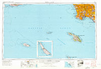
Long Beach, California, USGS topographic map dated 1957.
Includes geographic coordinates (latitude and longitude). This topographic map is suitable for hiking, camping, and exploring, or framing it as a wall map.
Printed on-demand using high resolution imagery, on heavy weight and acid free paper, or alternatively on a variety of synthetic materials.
Topos available on paper, Waterproof, Poly, or Tyvek. Usually shipping rolled, unless combined with other folded maps in one order.
- Product Number: USGS-5680583
- Free digital map download (high-resolution, GeoPDF): Long Beach, California (file size: 24 MB)
- Map Size: please refer to the dimensions of the GeoPDF map above
- Weight (paper map): ca. 55 grams
- Map Type: POD USGS Topographic Map
- Map Series: HTMC
- Map Verison: Historical
- Cell ID: 68880
- Scan ID: 299812
- Imprint Year: 1971
- Woodland Tint: Yes
- Edit Year: 1970
- Field Check Year: 1957
- Datum: Unstated
- Map Projection: Transverse Mercator
- Map published by United States Army Corps of Engineers
- Keywords: Inset
- Map Language: English
- Scanner Resolution: 600 dpi
- Map Cell Name: Long Beach
- Grid size: 1 X 2 Degree
- Date on map: 1957
- Map Scale: 1:250000
- Geographical region: California, United States
Neighboring Maps:
All neighboring USGS topo maps are available for sale online at a variety of scales.
Spatial coverage:
Topo map Long Beach, California, covers the geographical area associated the following places:
- Avalon Village - Watson Junction - Sunset Beach - Palisades Del Rey (historical) - Hermosa Beach - Portuguese Bend - San Pedro Hill - Laguna - Rolling Hills - Alla - Gardena - Pueblo Del Rio Public Housing - Rendalia - Carmenita - Thenard - Bandini - Pico Rivera - Monaco - Willowbrook - Redondo Beach - Maywood - Westmont - Bixby Knolls - Rolling Hills Estates - California Heights - Leisure World - Vinvale - Los Robles Mobile Home Park - Dominguez - Hollywood Riviera - Compton - Bell Gardens - Watson - Hyperion (historical) - Rossmoor - Wilmington - Lynwood Gardens - East Rancho Dominguez - Wingfoot - Nadeau - Cerritos - Imperial Courts - Playa Vista - Gage - Firestone Park - Hawaiian Gardens - Moneta - Lincoln Center Mobile Home Park - Seal Beach - Skandia Mobile Country Park - Two Harbors - Rose Park - Dolley - Ladera Heights - Friendly Hills - Bangle - South Gate - Southwest Village - South Whittier - McCampbell - Santa Fe Springs - Hansen - Huntington Harbour - Westchester - Seal Beach Trailer Park - Signal Hill - Avalon - San Pedro - El Nido - Elftman - Morningside Park - Clifton - West Carson - Dolores - Lomita - Colima - Workman - Graham - Athens - Playa del Rey - Inglewood - Motordrome (historical) - Clearwater - Belmont Heights - Wrigley - Palos Verdes Estates - Bell - Marina del Rey - Royal Oak Mobile Home Park - Alondra Park - Ocean View Estates - Strawberry Park - El Segundo - Los Nietos Junction - Lakewood - Paramount - Barber City - Manhattan Beach - Sea Aria West Mobile Home Estates - Halcon
- Map Area ID: AREA3433-120-118
- Northwest corner Lat/Long code: USGSNW34-120
- Northeast corner Lat/Long code: USGSNE34-118
- Southwest corner Lat/Long code: USGSSW33-120
- Southeast corner Lat/Long code: USGSSE33-118
- Northern map edge Latitude: 34
- Southern map edge Latitude: 33
- Western map edge Longitude: -120
- Eastern map edge Longitude: -118


