
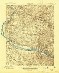
~ Seneca MD topo map, 1:62500 scale, 15 X 15 Minute, Historical, 1908, updated 1945
Seneca, Maryland, USGS topographic map dated 1908.
Includes geographic coordinates (latitude and longitude). This topographic map is suitable for hiking, camping, and exploring, or framing it as a wall map.
Printed on-demand using high resolution imagery, on heavy weight and acid free paper, or alternatively on a variety of synthetic materials.
Topos available on paper, Waterproof, Poly, or Tyvek. Usually shipping rolled, unless combined with other folded maps in one order.
- Product Number: USGS-5679509
- Free digital map download (high-resolution, GeoPDF): Seneca, Maryland (file size: 10 MB)
- Map Size: please refer to the dimensions of the GeoPDF map above
- Weight (paper map): ca. 55 grams
- Map Type: POD USGS Topographic Map
- Map Series: HTMC
- Map Verison: Historical
- Cell ID: 62332
- Scan ID: 257667
- Imprint Year: 1945
- Survey Year: 1907
- Datum: Unstated
- Map Projection: Polyconic
- Map published by United States Geological Survey
- Keywords: Overedge
- Map Language: English
- Scanner Resolution: 600 dpi
- Map Cell Name: Seneca
- Grid size: 15 X 15 Minute
- Date on map: 1908
- Map Scale: 1:62500
- Geographical region: Maryland, United States
Neighboring Maps:
All neighboring USGS topo maps are available for sale online at a variety of scales.
Spatial coverage:
Topo map Seneca, Maryland, covers the geographical area associated the following places:
- Ancient Oak North - Darnestown - Sellman - Greenridge Acres - Westerly - Seneca Chase - Quince Orchard Valley - Quince Orchard Manor - Lansdowne Town Center - Dickerson - Germantown - Glen Query - Broad Run Farms - Polo Club Estates - Running Brook Acres - Willow Ridge - Martinsburg - Spring Meadows - Esworthy Estates - University Center - Mills Farm - Quince Orchard - Belmont Country Club - Thompsons Corner - Natural Woods - Jerusalem - Travilah - Ridgeland Farm Estates - Riverwood - Esworthy Park - The Colony - Slidell - Liberty Heights - Darnestown Knolls - Germantown Estates - Countryside - Blackrock Estates - Waring (historical) - Leighs - Fountain View - Beau Monde Estates - Pioneer Hills - Lowes Island - Stoneridge - Wilber - Ashburn Junction - Ashburn Village - Mitchells Range - Deakins Range - Poolesville - Comus - Rushville - Sugarland - Seneca Highlands - Clarksbrook Estates - Pleasant Fields - Hartley Hall Estates - Farmingdale Estates - Clarksburg - Daysville (historical) - Deanwood - Mount Ephraim - Barnesville - Darnestown Hills - Kingsview Knolls - Seneca - Potomac Farms - Dulles Town Center - Germantown Park - Ashburn - Blackrock Hills - Old Germantown - Belvedere - Blocktown - Ancient Oak West - Lees Corner - Travilah Meadows - Sugarland Run - Sterling - Elizabeths Delight - Rive Gauche Estates - Mills Farm East - Germantown View - Brookmead North - Blackrock Mill - Brownstown Estates - Browns Corner - Black Hill - Wesmond - Tobytown - Boyds - Cedar Creek Estates - Brownstown - Ryan - Beallsville - Furnace Ford - Dranesville - Farmlands - Meadowbrook Estates - Sterling Park
- Map Area ID: AREA39.2539-77.5-77.25
- Northwest corner Lat/Long code: USGSNW39.25-77.5
- Northeast corner Lat/Long code: USGSNE39.25-77.25
- Southwest corner Lat/Long code: USGSSW39-77.5
- Southeast corner Lat/Long code: USGSSE39-77.25
- Northern map edge Latitude: 39.25
- Southern map edge Latitude: 39
- Western map edge Longitude: -77.5
- Eastern map edge Longitude: -77.25


