
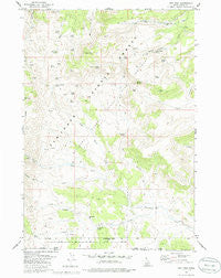
~ Ibex Peak ID topo map, 1:24000 scale, 7.5 X 7.5 Minute, Historical, 1977, updated 1986
Ibex Peak, Idaho, USGS topographic map dated 1977.
Includes geographic coordinates (latitude and longitude). This topographic map is suitable for hiking, camping, and exploring, or framing it as a wall map.
Printed on-demand using high resolution imagery, on heavy weight and acid free paper, or alternatively on a variety of synthetic materials.
Topos available on paper, Waterproof, Poly, or Tyvek. Usually shipping rolled, unless combined with other folded maps in one order.
- Product Number: USGS-5676728
- Free digital map download (high-resolution, GeoPDF): Ibex Peak, Idaho (file size: 12 MB)
- Map Size: please refer to the dimensions of the GeoPDF map above
- Weight (paper map): ca. 55 grams
- Map Type: POD USGS Topographic Map
- Map Series: HTMC
- Map Verison: Historical
- Cell ID: 21662
- Scan ID: 236605
- Imprint Year: 1986
- Woodland Tint: Yes
- Aerial Photo Year: 1972
- Edit Year: 1977
- Field Check Year: 1974
- Datum: NAD27
- Map Projection: Transverse Mercator
- Map published by United States Geological Survey
- Keywords: Overedge
- Map Language: English
- Scanner Resolution: 600 dpi
- Map Cell Name: Ibex Peak
- Grid size: 7.5 X 7.5 Minute
- Date on map: 1977
- Map Scale: 1:24000
- Geographical region: Idaho, United States
Neighboring Maps:
All neighboring USGS topo maps are available for sale online at a variety of scales.
Spatial coverage:
Topo map Ibex Peak, Idaho, covers the geographical area associated the following places:
- Triple Spring - Emery Ranch - Sage Hen Spring - Chalk Spring - Sheep Spring - Daves Pass Spring - Magpie Spring - N E Canyon - Ibex Peak - Johnnys Canyon - Lone Pine Spring - Left Hand Fork Beaverdam Creek - Carlson Canyon - N E Creek - Rock Spring - Point Spring - Carlson Creek - Wards Corral - Swede Spring - Dry Gulch - Section 9 Spring - Beaverdam Creek - Daves Pass - Mabey Spring - Twin Springs - Right Hand Fork Beaverdam Creek - Tent Spring - Beaverdam Pass - Dry Gulch Spring - Lone Cedar Spring - Frish Ranch - Worthington Mine - Mabey Spring Number 2 - Owens Corral Spring - Rodeo Spring - Hole in the Wall Spring - Beaverdam Pass Spring - Orangeburg Spring - N W Spring
- Map Area ID: AREA42.12542-114.125-114
- Northwest corner Lat/Long code: USGSNW42.125-114.125
- Northeast corner Lat/Long code: USGSNE42.125-114
- Southwest corner Lat/Long code: USGSSW42-114.125
- Southeast corner Lat/Long code: USGSSE42-114
- Northern map edge Latitude: 42.125
- Southern map edge Latitude: 42
- Western map edge Longitude: -114.125
- Eastern map edge Longitude: -114


