
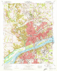
~ Florence AL topo map, 1:24000 scale, 7.5 X 7.5 Minute, Historical, 1971, updated 1972
Florence, Alabama, USGS topographic map dated 1971.
Includes geographic coordinates (latitude and longitude). This topographic map is suitable for hiking, camping, and exploring, or framing it as a wall map.
Printed on-demand using high resolution imagery, on heavy weight and acid free paper, or alternatively on a variety of synthetic materials.
Topos available on paper, Waterproof, Poly, or Tyvek. Usually shipping rolled, unless combined with other folded maps in one order.
- Product Number: USGS-5676455
- Free digital map download (high-resolution, GeoPDF): Florence, Alabama (file size: 17 MB)
- Map Size: please refer to the dimensions of the GeoPDF map above
- Weight (paper map): ca. 55 grams
- Map Type: POD USGS Topographic Map
- Map Series: HTMC
- Map Verison: Historical
- Cell ID: 15596
- Scan ID: 303852
- Imprint Year: 1972
- Woodland Tint: Yes
- Aerial Photo Year: 1967
- Field Check Year: 1971
- Datum: NAD27
- Map Projection: Polyconic
- Map published by United States Geological Survey
- Map published by Tennessee Valley Authority
- Keywords: Overedge
- Map Language: English
- Scanner Resolution: 600 dpi
- Map Cell Name: Florence
- Grid size: 7.5 X 7.5 Minute
- Date on map: 1971
- Map Scale: 1:24000
- Geographical region: Alabama, United States
Neighboring Maps:
All neighboring USGS topo maps are available for sale online at a variety of scales.
Spatial coverage:
Topo map Florence, Alabama, covers the geographical area associated the following places:
- McGee Town - Beechwood - Six Points - Northwood Park - Loyall (historical) - Underwood - Sherill Gardens - Beckman - Three Forks - North Florence - Easton - Cloverdale Heights - North Port (historical) - River Oaks - Underwood Estates - Morningdale - Chisholm Hills - Petersville - East Florence - Hickory Hills - Wilson Dam Village Number Three (historical) - Buckingham - Glendale Estates - Rose Park - Cypress Heights - Forest Hills - Northwood Hills - Windsor Heights - Fairview - Weeden Heights - Country Club Acres - Mansion View - Furnace Hill (historical) - Vestavia Gardens - Woodlawn Heights - Heathrow - Mars Hill - The Cedars - Edgemont - Alexander Heights - Twin Brooks - East Sheffield - Washington Park - Florence - Canaan (historical) - South Florence - Greenbrier - New Castle Estates - Windcrest - Sherwood Forest - Olland - Cypress Crest - Sheffield Heights - Sheffield - Briarcliff - Cliff Haven - Cypress Forest - Creekwood
- Map Area ID: AREA34.87534.75-87.75-87.625
- Northwest corner Lat/Long code: USGSNW34.875-87.75
- Northeast corner Lat/Long code: USGSNE34.875-87.625
- Southwest corner Lat/Long code: USGSSW34.75-87.75
- Southeast corner Lat/Long code: USGSSE34.75-87.625
- Northern map edge Latitude: 34.875
- Southern map edge Latitude: 34.75
- Western map edge Longitude: -87.75
- Eastern map edge Longitude: -87.625


