
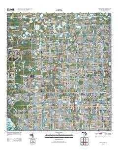
~ Citrus Park FL topo map, 1:24000 scale, 7.5 X 7.5 Minute, Historical, 2012
Citrus Park, Florida, USGS topographic map dated 2012.
Includes geographic coordinates (latitude and longitude). This topographic map is suitable for hiking, camping, and exploring, or framing it as a wall map.
Printed on-demand using high resolution imagery, on heavy weight and acid free paper, or alternatively on a variety of synthetic materials.
Topos available on paper, Waterproof, Poly, or Tyvek. Usually shipping rolled, unless combined with other folded maps in one order.
- Product Number: USGS-5675596
- Free digital map download (high-resolution, GeoPDF): Citrus Park, Florida (file size: 25 MB)
- Map Size: please refer to the dimensions of the GeoPDF map above
- Weight (paper map): ca. 55 grams
- Map Type: POD USGS Topographic Map
- Map Series: US Topo
- Map Verison: Historical
- Cell ID: 8828
- Datum: North American Datum of 1983
- Map Projection: Transverse Mercator
- Map Cell Name: Citrus Park
- Grid size: 7.5 X 7.5 Minute
- Date on map: 2012
- Map Scale: 1:24000
- Geographical region: Florida, United States
Neighboring Maps:
All neighboring USGS topo maps are available for sale online at a variety of scales.
Spatial coverage:
Topo map Citrus Park, Florida, covers the geographical area associated the following places:
- Cosme - Triple Lakes - Pine Crest Manor - Cypress Trace - Citrus Park Commons - Wingate Village - The Village West - Steeplechase - Andover Village - Hammock Woods - Fairway Village - Pinehurst Villas - Byars Heights - Top of the Village - Kirby Creek - Mohr Loop - Carrollwood Estates - Sandpiper - Bent Tree Place - Village Estates - Hudson Terrace - Himes Avenue Estates - Pennington Village - George Road Estates - Le Clare Estates - Northbridge at Lake Pretty - West Park Estates - Hampton Park - Oakwood Villa - Lowell Village - Andover - Yent - Solana Bay - Frenchs - Woodmont - Brentwood - Sunray Estates - Arbor Oaks - Carrillon Estates - Northlake Village - White Trout Lake Shores - Southfork at Van Dyke Farms - Reserve on Rock Lake - Sunshine Village - Oakmeadows West - Armistead Manor - Lake Maurine Estates - Arlington - Paddock Trail - Lake Leta Trace - Cypress Glen - Triple Lake Shores - Creekside - Hidden Lake - Orange Blossom Creek - Green Grass Acres - Spivey - Pinecrest Villa - Cypress Hollow - Beacon Meadows - Citrus Pointe - Carrollwood Village - Enclave at Citrus Park - The Cloister - Fountain Park - Twelve Oaks Village - Community Estates - Hidden Oaks - Northwest Park - Whispering Oaks - Longboat Landing - Oak View Terrace - Kirkland Acres - Traditions at Woodmont - Ehrlich Gardenlands - Hibiscus Gardens - The Landings of Tampa - Harr Estates - Trafalgar Square - Estates of Rock Lake - Citrus Park Crossing - Brightside Village - Canterbury - Morganwoods Garden Homes - Eastbrook - Keystone Groves - Arlington Oaks - Echo Lake Estates - Saint Andrews Square - Monaco Gardens - Villa Largo - Lake Crest Manor - Pat Acres - Belle Glen - Enclave of Carrollwood - Waterchase - Towne Place - Lake Julia - Rosemount Village - Levinson
- Map Area ID: AREA28.12528-82.625-82.5
- Northwest corner Lat/Long code: USGSNW28.125-82.625
- Northeast corner Lat/Long code: USGSNE28.125-82.5
- Southwest corner Lat/Long code: USGSSW28-82.625
- Southeast corner Lat/Long code: USGSSE28-82.5
- Northern map edge Latitude: 28.125
- Southern map edge Latitude: 28
- Western map edge Longitude: -82.625
- Eastern map edge Longitude: -82.5


