
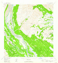
~ Talkeetna B 4 AK topo map, 1:63360 scale, 15 X 15 Minute, Historical, 1954, updated 1961
Talkeetna B 4, Alaska, USGS topographic map dated 1954.
Includes geographic coordinates (latitude and longitude). This topographic map is suitable for hiking, camping, and exploring, or framing it as a wall map.
Printed on-demand using high resolution imagery, on heavy weight and acid free paper, or alternatively on a variety of synthetic materials.
Topos available on paper, Waterproof, Poly, or Tyvek. Usually shipping rolled, unless combined with other folded maps in one order.
- Product Number: USGS-5673692
- Free digital map download (high-resolution, GeoPDF): Talkeetna B 4, Alaska (file size: 15 MB)
- Map Size: please refer to the dimensions of the GeoPDF map above
- Weight (paper map): ca. 55 grams
- Map Type: POD USGS Topographic Map
- Map Series: HTMC
- Map Verison: Historical
- Cell ID: 63258
- Scan ID: 359544
- Imprint Year: 1961
- Woodland Tint: Yes
- Aerial Photo Year: 1954
- Datum: NAD27
- Map Projection: Universal Transverse Mercator
- Map published by United States Geological Survey
- Map Language: English
- Scanner Resolution: 600 dpi
- Map Cell Name: Talkeetna B-4
- Grid size: 15 X 15 Minute
- Date on map: 1954
- Map Scale: 1:63360
- Geographical region: Alaska, United States
Neighboring Maps:
All neighboring USGS topo maps are available for sale online at a variety of scales.
Spatial coverage:
Topo map Talkeetna B 4, Alaska, covers the geographical area associated the following places:
- Colorado Creek - Fourth of July Creek - Rich Creek - West Fork Yentna River - Slate Creek - Orin Gulch - Wolverine Creek - Sunflower Basin - Fairview Mountain - Mount Kliskon - California Creek - Big Boulder Creek - Little Boulder Creek - Big Shookum Creek - Squirrel Creek - John Creek - Fergy Gulch - Chicago Gulch - Pass Creek - Flag Creek - Dome Creek - Wagner Gulch - Midway Lakes - Bonanza Creek - East Fork Yentna River - Cascade Creek
- Map Area ID: AREA62.562.25-152-151.5
- Northwest corner Lat/Long code: USGSNW62.5-152
- Northeast corner Lat/Long code: USGSNE62.5-151.5
- Southwest corner Lat/Long code: USGSSW62.25-152
- Southeast corner Lat/Long code: USGSSE62.25-151.5
- Northern map edge Latitude: 62.5
- Southern map edge Latitude: 62.25
- Western map edge Longitude: -152
- Eastern map edge Longitude: -151.5


