
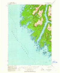
~ Sitka D 8 AK topo map, 1:63360 scale, 15 X 15 Minute, Historical, 1948, updated 1962
Sitka D 8, Alaska, USGS topographic map dated 1948.
Includes geographic coordinates (latitude and longitude). This topographic map is suitable for hiking, camping, and exploring, or framing it as a wall map.
Printed on-demand using high resolution imagery, on heavy weight and acid free paper, or alternatively on a variety of synthetic materials.
Topos available on paper, Waterproof, Poly, or Tyvek. Usually shipping rolled, unless combined with other folded maps in one order.
- Product Number: USGS-5673032
- Free digital map download (high-resolution, GeoPDF): Sitka D 8, Alaska (file size: 9 MB)
- Map Size: please refer to the dimensions of the GeoPDF map above
- Weight (paper map): ca. 55 grams
- Map Type: POD USGS Topographic Map
- Map Series: HTMC
- Map Verison: Historical
- Cell ID: 73141
- Scan ID: 359181
- Imprint Year: 1962
- Woodland Tint: Yes
- Aerial Photo Year: 1948
- Edit Year: 1961
- Datum: NAD27
- Map Projection: Universal Transverse Mercator
- Map published by United States Geological Survey
- Map Language: English
- Scanner Resolution: 600 dpi
- Map Cell Name: Sitka D-8
- Grid size: 15 X 15 Minute
- Date on map: 1948
- Map Scale: 1:63360
- Geographical region: Alaska, United States
Neighboring Maps:
All neighboring USGS topo maps are available for sale online at a variety of scales.
Spatial coverage:
Topo map Sitka D 8, Alaska, covers the geographical area associated the following places:
- Bohemia Creek - Zhilo Cove - Yakobi Peak - White Sulphur Springs Cabin - Skinner Island - Beric Island - White Crag Island - Mount Hill - Takanis Peak - Takanis Bay - Porcupine River - Porcupine Rock - Deer Harbor - Caution Passage - Wild Rice Lake - Mindalina Island - El Nido Peak - Urey Rocks - Esther Island - Winifred Island - Star Rock - Canoe Cove - Bertha Bay - Point Razbitie - Point Simonds - Point Theodore - Post Island - Cape Cross - Yakobi Island - Takanis Lake - Bohemia Basin - Point Partennoi - Threenob Rock - Goldwin Mine - Takanis Peninsula - Surge Bay - Point Satchrun - Stranger River - Islas Bay - Porcupine Bay - South Point - Porcupine Islands - Lumber Cove - Canoe Slough - Lisianski Strait - Lost Cove - Greentop Harbor - Squid Bay - Palmtree Islands - Point Urey - Green Top Cabin - White Sulphur Springs - Gauntlet Island - Greentop Island - Lake Helen - Canoe Pass - Sushilna Island - Point Dougherty - Takanis Creek - Ilin Bay - Tentree Island - Constantine Cove
- Map Area ID: AREA5857.75-136.6666667-136.3333333
- Northwest corner Lat/Long code: USGSNW58-136.6666667
- Northeast corner Lat/Long code: USGSNE58-136.3333333
- Southwest corner Lat/Long code: USGSSW57.75-136.6666667
- Southeast corner Lat/Long code: USGSSE57.75-136.3333333
- Northern map edge Latitude: 58
- Southern map edge Latitude: 57.75
- Western map edge Longitude: -136.6666667
- Eastern map edge Longitude: -136.3333333


