
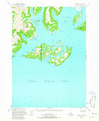
~ Seward D 1 AK topo map, 1:63360 scale, 15 X 15 Minute, Historical, 1951, updated 1965
Seward D 1, Alaska, USGS topographic map dated 1951.
Includes geographic coordinates (latitude and longitude). This topographic map is suitable for hiking, camping, and exploring, or framing it as a wall map.
Printed on-demand using high resolution imagery, on heavy weight and acid free paper, or alternatively on a variety of synthetic materials.
Topos available on paper, Waterproof, Poly, or Tyvek. Usually shipping rolled, unless combined with other folded maps in one order.
- Product Number: USGS-5672640
- Free digital map download (high-resolution, GeoPDF): Seward D 1, Alaska (file size: 8 MB)
- Map Size: please refer to the dimensions of the GeoPDF map above
- Weight (paper map): ca. 55 grams
- Map Type: POD USGS Topographic Map
- Map Series: HTMC
- Map Verison: Historical
- Cell ID: 62383
- Scan ID: 358980
- Imprint Year: 1965
- Woodland Tint: Yes
- Aerial Photo Year: 1950
- Edit Year: 1965
- Datum: NAD27
- Map Projection: Universal Transverse Mercator
- Map published by United States Geological Survey
- Map Language: English
- Scanner Resolution: 600 dpi
- Map Cell Name: Seward D-1
- Grid size: 15 X 15 Minute
- Date on map: 1951
- Map Scale: 1:63360
- Geographical region: Alaska, United States
Neighboring Maps:
All neighboring USGS topo maps are available for sale online at a variety of scales.
Spatial coverage:
Topo map Seward D 1, Alaska, covers the geographical area associated the following places:
- Slipper Point - Eickelberg Bay - Long Point - Irish Cove - Heather Island - Billys Hole - Flent Point - Elf Point - Long Bay - Cave Point - Growler Bay - Round Mountain - Chamberlain Bay - Buyers Cove - Bull Head - Schrader Island - Finski Bay - Jackson Hole - Elder Point - Eagle Bay - Heather Bay - Campbell Bay - Lutris Pass - Finski Point - Granite Cove - Emerald Cove - Useless Cove - Glacier Island - Columbia Bay - Iceberg Point - Jackson Cove
- Map Area ID: AREA6160.75-147.375-147
- Northwest corner Lat/Long code: USGSNW61-147.375
- Northeast corner Lat/Long code: USGSNE61-147
- Southwest corner Lat/Long code: USGSSW60.75-147.375
- Southeast corner Lat/Long code: USGSSE60.75-147
- Northern map edge Latitude: 61
- Southern map edge Latitude: 60.75
- Western map edge Longitude: -147.375
- Eastern map edge Longitude: -147


