
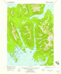
~ Petersburg A 2 AK topo map, 1:63360 scale, 15 X 15 Minute, Historical, 1948, updated 1957
Petersburg A 2, Alaska, USGS topographic map dated 1948.
Includes geographic coordinates (latitude and longitude). This topographic map is suitable for hiking, camping, and exploring, or framing it as a wall map.
Printed on-demand using high resolution imagery, on heavy weight and acid free paper, or alternatively on a variety of synthetic materials.
Topos available on paper, Waterproof, Poly, or Tyvek. Usually shipping rolled, unless combined with other folded maps in one order.
- Product Number: USGS-5671284
- Free digital map download (high-resolution, GeoPDF): Petersburg A 2, Alaska (file size: 10 MB)
- Map Size: please refer to the dimensions of the GeoPDF map above
- Weight (paper map): ca. 55 grams
- Map Type: POD USGS Topographic Map
- Map Series: HTMC
- Map Verison: Historical
- Cell ID: 60904
- Scan ID: 358286
- Imprint Year: 1957
- Woodland Tint: Yes
- Aerial Photo Year: 1948
- Datum: NAD27
- Map Projection: Universal Transverse Mercator
- Map published by United States Geological Survey
- Map Language: English
- Scanner Resolution: 600 dpi
- Map Cell Name: Petersburg A-2
- Grid size: 15 X 15 Minute
- Date on map: 1948
- Map Scale: 1:63360
- Geographical region: Alaska, United States
Neighboring Maps:
All neighboring USGS topo maps are available for sale online at a variety of scales.
Spatial coverage:
Topo map Petersburg A 2, Alaska, covers the geographical area associated the following places:
- Trout Creek - South Burnett Island - Virginia Peak - Hatchery Lake - Cooney Cove - Rocky Bay - McHenry Lake - Towayat's Village - Nut Rock - Cannery Point - Navy Lake - Fawn Island - Navy Peak - Porcupine Creek - Jadski Cove - Point Stanhope - Marble Point - Mosman Inlet - Isle Point - Falls Creek - Keating Range - Stanhope Island - Alice Peak - Burnett Inlet - Turn Island - Anita Bay - Streets Lake - Range Island - Anita Point - McHenry Islet - Mosman Point - Quiet Harbor - North Burnett Island - Burnett Lake - Etolin Island - Three Way Passage - Deadman Island - Mosman Island - McHenry Inlet - Olive Lake
- Map Area ID: AREA56.2556-132.6666667-132.3333333
- Northwest corner Lat/Long code: USGSNW56.25-132.6666667
- Northeast corner Lat/Long code: USGSNE56.25-132.3333333
- Southwest corner Lat/Long code: USGSSW56-132.6666667
- Southeast corner Lat/Long code: USGSSE56-132.3333333
- Northern map edge Latitude: 56.25
- Southern map edge Latitude: 56
- Western map edge Longitude: -132.6666667
- Eastern map edge Longitude: -132.3333333


