
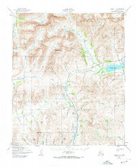
~ Nome D 1 AK topo map, 1:63360 scale, 15 X 15 Minute, Historical, 1950, updated 1974
Nome D 1, Alaska, USGS topographic map dated 1950.
Includes geographic coordinates (latitude and longitude). This topographic map is suitable for hiking, camping, and exploring, or framing it as a wall map.
Printed on-demand using high resolution imagery, on heavy weight and acid free paper, or alternatively on a variety of synthetic materials.
Topos available on paper, Waterproof, Poly, or Tyvek. Usually shipping rolled, unless combined with other folded maps in one order.
- Product Number: USGS-5670872
- Free digital map download (high-resolution, GeoPDF): Nome D 1, Alaska (file size: 20 MB)
- Map Size: please refer to the dimensions of the GeoPDF map above
- Weight (paper map): ca. 55 grams
- Map Type: POD USGS Topographic Map
- Map Series: HTMC
- Map Verison: Historical
- Cell ID: 60288
- Scan ID: 358071
- Imprint Year: 1974
- Woodland Tint: Yes
- Aerial Photo Year: 1950
- Edit Year: 1972
- Datum: NAD27
- Map Projection: Universal Transverse Mercator
- Map published by United States Geological Survey
- Map published by United States Army Corps of Engineers
- Map published by United States Army
- Map Language: English
- Scanner Resolution: 600 dpi
- Map Cell Name: Nome D-1
- Grid size: 15 X 15 Minute
- Date on map: 1950
- Map Scale: 1:63360
- Geographical region: Alaska, United States
Neighboring Maps:
All neighboring USGS topo maps are available for sale online at a variety of scales.
Spatial coverage:
Topo map Nome D 1, Alaska, covers the geographical area associated the following places:
- Wet Gulch - Jett Creek - Clara Creek - Copper Mountain - Sulphur Creek - Monte Cristo Creek - Short Creek - Dorothy Creek - Rock Creek - Bonanza Creek - Gold Run - Black Top - Tigaraha Mountain - Warren Creek - North Fork Grand Central River - McLellan Creek - Salmon Lake Airport - Wild Goose Pipeline - North Star Creek - Slate Creek - Rocky Mountain Creek - North Fork Fox Creek - July Gulch - Thompson Creek - Fox Creek - David Creek - Little Gulch - Windy Creek - Kigluaik Mountains - Boulder Creek - Fred Creek - Jensens Cemetery - Hill Gulch - Jasper Creek - Rainbow Creek - Windy Creek - Mount Distin - West Fork Grand Central River - Deep Canyon Creek - Tumit Creek - Grand Central River - Hudson Creek - Mosquito Pass - Short Creek - Dickens Creek - Jack Gulch - Alfield Creek - Christian Creek - Canine Gulch - Nugget Creek - Divide Creek - Francisco Creek - Morning Call Creek - Quartz Creek - Berkley Canyon - Mount Osborn - Buffalo Creek - Silver Creek - Paso Robles Creek - Mountain Creek - Boer Creek - Crater Lake - Jensens Camp - Lost Creek - Thompson Creek - Copper Creek
- Map Area ID: AREA6564.75-165.5-165
- Northwest corner Lat/Long code: USGSNW65-165.5
- Northeast corner Lat/Long code: USGSNE65-165
- Southwest corner Lat/Long code: USGSSW64.75-165.5
- Southeast corner Lat/Long code: USGSSE64.75-165
- Northern map edge Latitude: 65
- Southern map edge Latitude: 64.75
- Western map edge Longitude: -165.5
- Eastern map edge Longitude: -165


