
~ Mount McKinley B 1 AK topo map, 1:63360 scale, 15 X 15 Minute, Historical, 1954, updated 1995
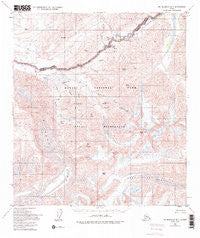
Mount McKinley B 1, Alaska, USGS topographic map dated 1954.
Includes geographic coordinates (latitude and longitude). This topographic map is suitable for hiking, camping, and exploring, or framing it as a wall map.
Printed on-demand using high resolution imagery, on heavy weight and acid free paper, or alternatively on a variety of synthetic materials.
Topos available on paper, Waterproof, Poly, or Tyvek. Usually shipping rolled, unless combined with other folded maps in one order.
- Product Number: USGS-5670290
- Free digital map download (high-resolution, GeoPDF): Mount McKinley B 1, Alaska (file size: 20 MB)
- Map Size: please refer to the dimensions of the GeoPDF map above
- Weight (paper map): ca. 55 grams
- Map Type: POD USGS Topographic Map
- Map Series: HTMC
- Map Verison: Historical
- Cell ID: 58055
- Scan ID: 357878
- Imprint Year: 1995
- Woodland Tint: Yes
- Aerial Photo Year: 1952
- Edit Year: 1995
- Datum: NAD27
- Map Projection: Transverse Mercator
- Map published by United States Geological Survey
- Map Language: English
- Scanner Resolution: 600 dpi
- Map Cell Name: Denali B-1
- Grid size: 15 X 15 Minute
- Date on map: 1954
- Map Scale: 1:63360
- Geographical region: Alaska, United States
Neighboring Maps:
All neighboring USGS topo maps are available for sale online at a variety of scales.
Spatial coverage:
Topo map Mount McKinley B 1, Alaska, covers the geographical area associated the following places:
- Stony Hill Overlook - Intermittent Creek - Contact Creek - Sunrise Glacier - Little Stony Creek - Camp Creek - Thorofare Pass - Mount Eielson - Divide Mountain - Green Dome - Anderson Pass - Red Mountain - Sunrise Creek - Sunset Peak - Stony Dome - Gorge Creek - Granite Creek - Eielson Visitor Center - Glacier Creek - Highway Pass - Thorofare River Patrol Cabin - Whistler Creek - Crystal Creek - Bergh Lake - The Notch - Wolverine Creek - Grant Creek - Fault Creek - Sunset Glacier - Copper Mountain Bar - West Fork Glacier - Scott Peak - Bald Mountain - Mount Galen - Castle Rock - Stony Hill - Gravel Mountain - Green Point
- Map Area ID: AREA63.563.25-150.5-150
- Northwest corner Lat/Long code: USGSNW63.5-150.5
- Northeast corner Lat/Long code: USGSNE63.5-150
- Southwest corner Lat/Long code: USGSSW63.25-150.5
- Southeast corner Lat/Long code: USGSSE63.25-150
- Northern map edge Latitude: 63.5
- Southern map edge Latitude: 63.25
- Western map edge Longitude: -150.5
- Eastern map edge Longitude: -150


