
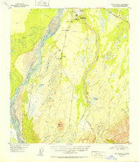
~ Mount Hayes D 4 AK topo map, 1:63360 scale, 15 X 15 Minute, Historical, 1952
Mount Hayes D 4, Alaska, USGS topographic map dated 1952.
Includes geographic coordinates (latitude and longitude). This topographic map is suitable for hiking, camping, and exploring, or framing it as a wall map.
Printed on-demand using high resolution imagery, on heavy weight and acid free paper, or alternatively on a variety of synthetic materials.
Topos available on paper, Waterproof, Poly, or Tyvek. Usually shipping rolled, unless combined with other folded maps in one order.
- Product Number: USGS-5670124
- Free digital map download (high-resolution, GeoPDF): Mount Hayes D 4, Alaska (file size: 15 MB)
- Map Size: please refer to the dimensions of the GeoPDF map above
- Weight (paper map): ca. 55 grams
- Map Type: POD USGS Topographic Map
- Map Series: HTMC
- Map Verison: Historical
- Cell ID: 58009
- Scan ID: 357687
- Woodland Tint: Yes
- Aerial Photo Year: 1949
- Datum: NAD27
- Map Projection: Universal Transverse Mercator
- Map published by United States Geological Survey
- Map Language: English
- Scanner Resolution: 600 dpi
- Map Cell Name: Mount Hayes D-4
- Grid size: 15 X 15 Minute
- Date on map: 1952
- Map Scale: 1:63360
- Geographical region: Alaska, United States
Neighboring Maps:
All neighboring USGS topo maps are available for sale online at a variety of scales.
Spatial coverage:
Topo map Mount Hayes D 4, Alaska, covers the geographical area associated the following places:
- Meadows Road Number 3 Lake - Till Valley - Meadows Road Number 4 Lake - Cavalry Lake - Bullwinkle Lake - No Mercy Lake - Fort Greely Fire and Emergency Services - Donnelly Dome - Sheefish Lake - Nickel Lake - Rockhound Lake - Butch Lake - Doc Lake - Ober Creek - Fort Greely Census Designated Place - North Twin Lake - Chet Lake - South Twin Lake - Donnelly Lake - Luke Lake - Ghost Lake - Fort Greely Post Office - J Lake - Bolio Lake - Allen Army Airfield - Big Lake - Mark Lake - Pumping Station Number 9 - Artillery Lake - Stryker Lake
- Map Area ID: AREA6463.75-146-145.5
- Northwest corner Lat/Long code: USGSNW64-146
- Northeast corner Lat/Long code: USGSNE64-145.5
- Southwest corner Lat/Long code: USGSSW63.75-146
- Southeast corner Lat/Long code: USGSSE63.75-145.5
- Northern map edge Latitude: 64
- Southern map edge Latitude: 63.75
- Western map edge Longitude: -146
- Eastern map edge Longitude: -145.5


