
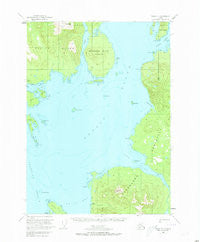
~ Craig D 1 AK topo map, 1:63360 scale, 15 X 15 Minute, Historical, 1949, updated 1973
Craig D 1, Alaska, USGS topographic map dated 1949.
Includes geographic coordinates (latitude and longitude). This topographic map is suitable for hiking, camping, and exploring, or framing it as a wall map.
Printed on-demand using high resolution imagery, on heavy weight and acid free paper, or alternatively on a variety of synthetic materials.
Topos available on paper, Waterproof, Poly, or Tyvek. Usually shipping rolled, unless combined with other folded maps in one order.
- Product Number: USGS-5665420
- Free digital map download (high-resolution, GeoPDF): Craig D 1, Alaska (file size: 9 MB)
- Map Size: please refer to the dimensions of the GeoPDF map above
- Weight (paper map): ca. 55 grams
- Map Type: POD USGS Topographic Map
- Map Series: HTMC
- Map Verison: Historical
- Cell ID: 53045
- Scan ID: 355309
- Imprint Year: 1973
- Woodland Tint: Yes
- Aerial Photo Year: 1948
- Edit Year: 1961
- Datum: NAD27
- Map Projection: Universal Transverse Mercator
- Map published by United States Geological Survey
- Map Language: English
- Scanner Resolution: 600 dpi
- Map Cell Name: Craig D-1
- Grid size: 15 X 15 Minute
- Date on map: 1949
- Map Scale: 1:63360
- Geographical region: Alaska, United States
Neighboring Maps:
All neighboring USGS topo maps are available for sale online at a variety of scales.
Spatial coverage:
Topo map Craig D 1, Alaska, covers the geographical area associated the following places:
- Hofstad Creek - McHenry Ledge - Lemesurier Point - Canoe Passage - Misery Island - Petersen Islands - Mount Shakes - Change Island - Watkins Point - Brownson Peak - Mount Burnett - Lemly Rocks - Easterly Island - Eaton Point - Stone Islands - Vixen Harbor - Vixen Point - Shakes Village - Union Point - Magnetic Point - Ernest Sound - Point Peters - Onslow Point - Brownson Island - Emerald Bay - Eagle Island - Vixen Inlet - Cannery Creek - Muffin Islands - Union Bay - Westerly Island - Sunshine Island - Canoe Pass
- Map Area ID: AREA5655.75-132.3333333-132
- Northwest corner Lat/Long code: USGSNW56-132.3333333
- Northeast corner Lat/Long code: USGSNE56-132
- Southwest corner Lat/Long code: USGSSW55.75-132.3333333
- Southeast corner Lat/Long code: USGSSE55.75-132
- Northern map edge Latitude: 56
- Southern map edge Latitude: 55.75
- Western map edge Longitude: -132.3333333
- Eastern map edge Longitude: -132


