
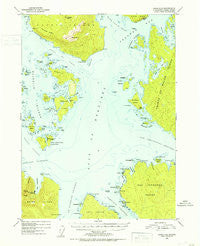
~ Craig C 5 AK topo map, 1:63360 scale, 15 X 15 Minute, Historical, 1951, updated 1953
Craig C 5, Alaska, USGS topographic map dated 1951.
Includes geographic coordinates (latitude and longitude). This topographic map is suitable for hiking, camping, and exploring, or framing it as a wall map.
Printed on-demand using high resolution imagery, on heavy weight and acid free paper, or alternatively on a variety of synthetic materials.
Topos available on paper, Waterproof, Poly, or Tyvek. Usually shipping rolled, unless combined with other folded maps in one order.
- Product Number: USGS-5665404
- Free digital map download (high-resolution, GeoPDF): Craig C 5, Alaska (file size: 7 MB)
- Map Size: please refer to the dimensions of the GeoPDF map above
- Weight (paper map): ca. 55 grams
- Map Type: POD USGS Topographic Map
- Map Series: HTMC
- Map Verison: Historical
- Cell ID: 72855
- Scan ID: 355301
- Imprint Year: 1953
- Woodland Tint: Yes
- Aerial Photo Year: 1948
- Datum: NAD27
- Map Projection: Universal Transverse Mercator
- Map published by United States Geological Survey
- Map Language: English
- Scanner Resolution: 600 dpi
- Map Cell Name: Craig C-5
- Grid size: 15 X 15 Minute
- Date on map: 1951
- Map Scale: 1:63360
- Geographical region: Alaska, United States
Neighboring Maps:
All neighboring USGS topo maps are available for sale online at a variety of scales.
Spatial coverage:
Topo map Craig C 5, Alaska, covers the geographical area associated the following places:
- Steamboat Point - Esquibel Island - Derrumba Ridge - Nossuk Anchorage - Princesa Island - Harmony Islands - Bocas De Finas - Aguirre Bay - Nagasay Cove - Tonowek Ridge - San Lorenzo Islands - San Christoval Channel - Bushtop Island - Salt Lake Bay - Noyes Island Cannery - Hacha Island - Escurial Island - Bay Point - Blanquizal Islands - Twocrack Island - Point Delgada - Point San Francisco - Hole in the Wall - Blanquizal Point - San Fernando Island - Pesquera Island - Steamboat Bay Seaplane Base - Point Garcia - Kabanof Rocks - Warm Chuck Inlet - Turtle Island - Garcia Island - Alargate Rocks - Gulf of Esquibel - Anguilla Bay - Steamboat Bay - Flotilla Island - Bald Mountain - Abrejo Rocks - Arriaga Passage - Dome Islets - Maurelle Islands Wilderness - Bobs Point - Trasera Island - Point Marabilla - Noyes Peak - Garita Rock - Animas Island - West San Lorenzo Island - Tonowek Bay - Curacao Reef - Launch Passage - Point Desconocida - East San Lorenzo Island - Palisade Island - Caracol Island - Bobs Place - Beta Rock - Point Incarnation - Hermagos Islands - Culebra Islands - Anguilla Island - Garcia Cove - Lambda Rock - Maurelle Islands - Point Aguirre - Sonora Island - Dead Tree Point - Point Santa Rosalia - White Cliff - Palisade Point - Moke Rock - Nossuk Bay - Point Animas - Desconocida Reef - Kubanof Rock - Tonina Island - Marabilla Island - Sonora Passage - Snail Point - Saint Philip Island - Phillips Rock - Point Santa Lucia - Point San Pasqual - Quitasueno Rock - Point Santa Gertrudis - Toza Island - Timber Knob
- Map Area ID: AREA55.7555.5-133.6666667-133.3333333
- Northwest corner Lat/Long code: USGSNW55.75-133.6666667
- Northeast corner Lat/Long code: USGSNE55.75-133.3333333
- Southwest corner Lat/Long code: USGSSW55.5-133.6666667
- Southeast corner Lat/Long code: USGSSE55.5-133.3333333
- Northern map edge Latitude: 55.75
- Southern map edge Latitude: 55.5
- Western map edge Longitude: -133.6666667
- Eastern map edge Longitude: -133.3333333


