
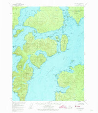
~ Craig B 5 AK topo map, 1:63360 scale, 15 X 15 Minute, Historical, 1948, updated 1974
Craig B 5, Alaska, USGS topographic map dated 1948.
Includes geographic coordinates (latitude and longitude). This topographic map is suitable for hiking, camping, and exploring, or framing it as a wall map.
Printed on-demand using high resolution imagery, on heavy weight and acid free paper, or alternatively on a variety of synthetic materials.
Topos available on paper, Waterproof, Poly, or Tyvek. Usually shipping rolled, unless combined with other folded maps in one order.
- Product Number: USGS-5665348
- Free digital map download (high-resolution, GeoPDF): Craig B 5, Alaska (file size: 12 MB)
- Map Size: please refer to the dimensions of the GeoPDF map above
- Weight (paper map): ca. 55 grams
- Map Type: POD USGS Topographic Map
- Map Series: HTMC
- Map Verison: Historical
- Cell ID: 72853
- Scan ID: 355273
- Imprint Year: 1974
- Woodland Tint: Yes
- Aerial Photo Year: 1948
- Edit Year: 1973
- Datum: NAD27
- Map Projection: Universal Transverse Mercator
- Map published by United States Geological Survey
- Map Language: English
- Scanner Resolution: 600 dpi
- Map Cell Name: Craig B-5
- Grid size: 15 X 15 Minute
- Date on map: 1948
- Map Scale: 1:63360
- Geographical region: Alaska, United States
Neighboring Maps:
All neighboring USGS topo maps are available for sale online at a variety of scales.
Spatial coverage:
Topo map Craig B 5, Alaska, covers the geographical area associated the following places:
- Reef Point - Thimble Cove - Muerta Island - Saint Nicholas Point - Canal Point - Point Remedios - Point Rosary - Fawn Mountain - Veta Point - Port Dolores - Saint Ignace Rock - Bibora Island - Pepper Point - Point Saint Boniface - Point Arucenas - Point Santa Rosa - Point Cangrejo - Point San Rafael - Ubi Island - Point Cruz - Point Amargura - Isidor Hill - Sola Rock - Point Saint Thomas - Dalton Hot Springs - Pimenta Mountain - Esmeralda Mountain - Saint Nicholas Channel - Bucareli Bay - Cone Island - Coposo Island - Point San Roque - Triste Point - Lulu Island - Indiada Island - San Clemente Island - Mineral Point - Point Cosinas - Saint Ignace Island - Point San Jose - Point Caponeta - Silvester Point - Point Gorda - Baker Island - Point San Leonardo - Port Asumcion - Port Santa Cruz - Punishment Point - Rana Reef - Point Fortaleza - Fortaleza Bay - Point Caracol - Point Saint Isidor - Arrecife Point - Port Real Marina - Point Cocos - Siketi Point - Cristina Island - Twin Rocks - Gaviota Rock - Paloma Pass - Siketi Sound - Rio de la Aguada - Sucia Ledge - Arroyo Blanco - Triste Island - Point Espada - Arboles Island - Arrecife Islands - Lake Fortaleza - Point Quemada - Pigeon Island - San Francisco Island - Point Santa Theresa - Point Fula - Santa Rita Island - Labandera Rock - Suemez Island - Port San Antonio - Mount Miramar - Point Isleta - Point Maria - Port San Antonio - Fortaleza Ridge - Indiada Cove - Kelly Cove - Point Falfan - Veta Bay - Amarilla Point - Point Barrigon - Pine Island - Point Arboleda - Port Mayoral - Sword Point - Aguada Cove - Cabras Islands - Point Capones - Portillo Channel - Point Alonzo - Isleta
- Map Area ID: AREA55.555.25-133.6666667-133.3333333
- Northwest corner Lat/Long code: USGSNW55.5-133.6666667
- Northeast corner Lat/Long code: USGSNE55.5-133.3333333
- Southwest corner Lat/Long code: USGSSW55.25-133.6666667
- Southeast corner Lat/Long code: USGSSE55.25-133.3333333
- Northern map edge Latitude: 55.5
- Southern map edge Latitude: 55.25
- Western map edge Longitude: -133.6666667
- Eastern map edge Longitude: -133.3333333


