
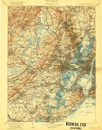
~ Passaic NJ topo map, 1:125000 scale, 30 X 30 Minute, Historical, 1905, updated 1922
Passaic, New Jersey, USGS topographic map dated 1905.
Includes geographic coordinates (latitude and longitude). This topographic map is suitable for hiking, camping, and exploring, or framing it as a wall map.
Printed on-demand using high resolution imagery, on heavy weight and acid free paper, or alternatively on a variety of synthetic materials.
Topos available on paper, Waterproof, Poly, or Tyvek. Usually shipping rolled, unless combined with other folded maps in one order.
- Product Number: USGS-5658980
- Free digital map download (high-resolution, GeoPDF): Passaic, New Jersey (file size: 12 MB)
- Map Size: please refer to the dimensions of the GeoPDF map above
- Weight (paper map): ca. 55 grams
- Map Type: POD USGS Topographic Map
- Map Series: HTMC
- Map Verison: Historical
- Cell ID: 66431
- Scan ID: 255445
- Imprint Year: 1922
- Survey Year: 1903
- Datum: Unstated
- Map Projection: Unstated
- Map published by United States Geological Survey
- Keywords: Overedge
- Map Language: English
- Scanner Resolution: 600 dpi
- Map Cell Name: Passaic
- Grid size: 30 X 30 Minute
- Date on map: 1905
- Map Scale: 1:125000
- Geographical region: New Jersey, United States
Neighboring Maps:
All neighboring USGS topo maps are available for sale online at a variety of scales.
Spatial coverage:
Topo map Passaic, New Jersey, covers the geographical area associated the following places:
- Iselin - New Dorp - Montclair Heights - Carteret - New York - Sunnyside - Fairfield - Rutherford - West Bergen - Overlook - Old Place - Jacksonville - Preakness - Emerson - New Vernon - Maplewood - Clark - Marcella - Red Hook Houses - North Bergen - Bonhamtown - Packanack Lake - Ridgefield - Great Notch - Hudson Heights - Grymes Hill - Malapardis - Hazelton - Brookdale - Avenel - Westwood - Eltingville - Beach Glen - Middlesex - Riverview Manor - Pumptown - Wayne - Possumtown - Richmond Valley - Troy Hills - Gillette - Hanover Neck - Marion - Oak Tree - Whippany - Boynton Beach - Northfield - Pompton Plains - Christopher Columbus Homes - New Providence - Pleasantville - Roseland - Little Ferry - New Brighton - Union City - Madison Heights - Graniteville - Perth Amboy - Washingtonville - Cedar Grove - Lake View - Paramus - Travis - Cherry Hill - Delawanna - Saddle Brook - Annadale - Jersey City - Mountain View - The Village at Little Falls - Kingsland - Clara Barton - Oradell - Tribeca - Ridgefield Park - Lyndhurst - Dyker Heights - Towaco - Richmond Terrace Houses - Seaside - Dongan Hills - Greenville - Society Hill - Riverdale - Carlstadt - West View - Saint George - Metropolitan Mobile Home Park - Vauxhall - North Caldwell - Chatham - Riverside - Tremont Park - Montclair - Netherwood - Nixon - Arlington - Winfield - Concord - Colonia
- Map Area ID: AREA4140.5-74.5-74
- Northwest corner Lat/Long code: USGSNW41-74.5
- Northeast corner Lat/Long code: USGSNE41-74
- Southwest corner Lat/Long code: USGSSW40.5-74.5
- Southeast corner Lat/Long code: USGSSE40.5-74
- Northern map edge Latitude: 41
- Southern map edge Latitude: 40.5
- Western map edge Longitude: -74.5
- Eastern map edge Longitude: -74


