
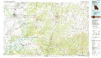
~ Neosho MO topo map, 1:100000 scale, 30 X 60 Minute, Historical, 1986, updated 1990
Neosho, Missouri, USGS topographic map dated 1986.
Includes geographic coordinates (latitude and longitude). This topographic map is suitable for hiking, camping, and exploring, or framing it as a wall map.
Printed on-demand using high resolution imagery, on heavy weight and acid free paper, or alternatively on a variety of synthetic materials.
Topos available on paper, Waterproof, Poly, or Tyvek. Usually shipping rolled, unless combined with other folded maps in one order.
- Product Number: USGS-5658654
- Free digital map download (high-resolution, GeoPDF): Neosho, Missouri (file size: 29 MB)
- Map Size: please refer to the dimensions of the GeoPDF map above
- Weight (paper map): ca. 55 grams
- Map Type: POD USGS Topographic Map
- Map Series: HTMC
- Map Verison: Historical
- Cell ID: 68035
- Scan ID: 325388
- Imprint Year: 1990
- Woodland Tint: Yes
- Aerial Photo Year: 1980
- Edit Year: 1986
- Datum: NAD27
- Map Projection: Universal Transverse Mercator
- Map published by United States Geological Survey
- Keywords: Overedge
- Map Language: English
- Scanner Resolution: 600 dpi
- Map Cell Name: Neosho
- Grid size: 30 X 60 Minute
- Date on map: 1986
- Map Scale: 1:100000
- Geographical region: Missouri, United States
Neighboring Maps:
All neighboring USGS topo maps are available for sale online at a variety of scales.
Spatial coverage:
Topo map Neosho, Missouri, covers the geographical area associated the following places:
- Cardin (historical) - Riverside Inn - Racine - Aroma - Cyclone - Splitlog - Cleora - North Miami - Wanda - Spring Valley - Christopher - Eastside - Armstrong Quarry - Diamond - Yonkerville - Hornet - Stark City - Powell - Berwick - Cayuga - South West City - Noel - Poole Ford - Cove - Ogeechee - Ottawa - Newtonia - Stella - May - Monark Springs - Afton - Grangeville (historical) - Lanagan - Newstead (historical) - Pierce City - McCullough Ford - Wylie - Jacket - Mills (historical) - Dodge - Douthat (historical) - Picher (historical) - Goodman - Simcoe - Grove - Belfast - McElhany - Five Mile - Cartmell (historical) - Elliff - Copeland - El Paso (historical) - Turkey Ford - Spring City - Dotyville - Dessa - Granby - Wentworth - Quapaw - Enterprise (historical) - Ritchey - Loma Linda - Moreville - Wyandotte - Tipton Ford - Wadell - Fredville - Kellyville - Sweetwater - Erie - Miami - Ridgley - Wheaton - Bethlehem - Sunrise - Westview - Wela Park - Rocky Comfort - June - Kelley Springs - Zincville (historical) - Jolly - Griffin Ford - Lincolnville - Longview - Seneca Quapaw Agency (historical) - Fairview - Center Point - Sugar Beach - Neosho - Coy - Mount Shira - Crag O Lea - Chester (historical) - Peoria - Havenhurst - Dennis - Quinn (historical) - Mayflower - Bernice
- Map Area ID: AREA3736.5-95-94
- Northwest corner Lat/Long code: USGSNW37-95
- Northeast corner Lat/Long code: USGSNE37-94
- Southwest corner Lat/Long code: USGSSW36.5-95
- Southeast corner Lat/Long code: USGSSE36.5-94
- Northern map edge Latitude: 37
- Southern map edge Latitude: 36.5
- Western map edge Longitude: -95
- Eastern map edge Longitude: -94


