
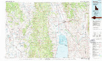
~ Preston ID topo map, 1:100000 scale, 30 X 60 Minute, Historical, 1983, updated 1983
Preston, Idaho, USGS topographic map dated 1983.
Includes geographic coordinates (latitude and longitude). This topographic map is suitable for hiking, camping, and exploring, or framing it as a wall map.
Printed on-demand using high resolution imagery, on heavy weight and acid free paper, or alternatively on a variety of synthetic materials.
Topos available on paper, Waterproof, Poly, or Tyvek. Usually shipping rolled, unless combined with other folded maps in one order.
- Product Number: USGS-5658327
- Free digital map download (high-resolution, GeoPDF): Preston, Idaho (file size: 31 MB)
- Map Size: please refer to the dimensions of the GeoPDF map above
- Weight (paper map): ca. 55 grams
- Map Type: POD USGS Topographic Map
- Map Series: HTMC
- Map Verison: Historical
- Cell ID: 68191
- Scan ID: 239413
- Imprint Year: 1983
- Woodland Tint: Yes
- Aerial Photo Year: 1977
- Edit Year: 1983
- Datum: NAD27
- Map Projection: Universal Transverse Mercator
- Map published by United States Geological Survey
- Keywords: Overedge
- Map Language: English
- Scanner Resolution: 600 dpi
- Map Cell Name: Preston
- Grid size: 30 X 60 Minute
- Date on map: 1983
- Map Scale: 1:100000
- Geographical region: Idaho, United States
Neighboring Maps:
All neighboring USGS topo maps are available for sale online at a variety of scales.
Spatial coverage:
Topo map Preston, Idaho, covers the geographical area associated the following places:
- Preston - Border Junction - Bear Lake Hot Springs - Glencoe - Lago - Winder - Glendale - Giveout - Lanark - Paris - Mapleton - Nounan - Sharon - Dayton - Weston - Egypt - Montpelier - Lindsayville - Saint Charles - Whitney - Alton - Thatcher - Bloomington - Bern - Treasureton - Fairview - Chausse - Harer - Dingle - Swan Lake - Georgetown - Cherryville - Mink Creek - Franklin - Silver Star - Bennington - Nashville - Raymond - Fish Haven - Wooleys - Novene - Riverdale - Ovid - Banida - Lifton - Turnpike - Cleveland - Geneva - Mound Valley - Anderson - Bear Lake Sands - Border - Wardboro - Liberty - Coulam - Pegram - Thorenson
- Map Area ID: AREA42.542-112-111
- Northwest corner Lat/Long code: USGSNW42.5-112
- Northeast corner Lat/Long code: USGSNE42.5-111
- Southwest corner Lat/Long code: USGSSW42-112
- Southeast corner Lat/Long code: USGSSE42-111
- Northern map edge Latitude: 42.5
- Southern map edge Latitude: 42
- Western map edge Longitude: -112
- Eastern map edge Longitude: -111


