
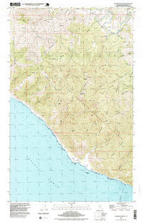
~ Shubrick Peak CA topo map, 1:24000 scale, 7.5 X 7.5 Minute, Historical, 1997, updated 1999
Shubrick Peak, California, USGS topographic map dated 1997.
Includes geographic coordinates (latitude and longitude). This topographic map is suitable for hiking, camping, and exploring, or framing it as a wall map.
Printed on-demand using high resolution imagery, on heavy weight and acid free paper, or alternatively on a variety of synthetic materials.
Topos available on paper, Waterproof, Poly, or Tyvek. Usually shipping rolled, unless combined with other folded maps in one order.
- Product Number: USGS-5658009
- Free digital map download (high-resolution, GeoPDF): Shubrick Peak, California (file size: 21 MB)
- Map Size: please refer to the dimensions of the GeoPDF map above
- Weight (paper map): ca. 55 grams
- Map Type: POD USGS Topographic Map
- Map Series: HTMC
- Map Verison: Historical
- Cell ID: 332111
- Scan ID: 295194
- Imprint Year: 1999
- Woodland Tint: Yes
- Aerial Photo Year: 1997
- Datum: NAD27
- Map Projection: Universal Transverse Mercator
- Map published by United States Geological Survey
- Map Language: English
- Scanner Resolution: 600 dpi
- Map Cell Name: Shubrick Peak
- Grid size: 7.5 X 7.5 Minute
- Date on map: 1997
- Map Scale: 1:24000
- Geographical region: California, United States
Neighboring Maps:
All neighboring USGS topo maps are available for sale online at a variety of scales.
Spatial coverage:
Topo map Shubrick Peak, California, covers the geographical area associated the following places:
- King Range Wilderness - Big Flat Creek - Oat Ridge - Kinsey Ridge - Big Flat - Woods Creek - Miller Ridge - Moody Ridge - Hadley Peak - California Department of Forestry and Fire Protection Mattole Station - Harris Ridge - Delgada Canyon - North Fork Big Flat Creek - Cook Ridge - Moorehead Ridge - Telegraph Ridge - Tan Oak Ridge - Pinnacle Spring - North Slide Peak - Big Creek - Fiddle Prairie - Shipman Creek - Green Ridge - Bear Trap Ridge - Black Rock - Oat Hill - King Range - Big Mountain - Shubrick Peak - Kendall Gulch - West Fork Honeydew Creek - Little Moorehead Ridge - Honeydew Volunteer Fire Company - King Crest Trail - Upper North Fork Mattole River - Bundle Prairie - Miller Flat - Upper North Fork Honeydew Creek - Rocks and Islands Wilderness - Shubrick Rock - Kinsey Creek - Brushy Mountain - Rattlesnake Ridge - Oat Creek
- Map Area ID: AREA40.2540.1-124.25-124.125
- Northwest corner Lat/Long code: USGSNW40.25-124.25
- Northeast corner Lat/Long code: USGSNE40.25-124.125
- Southwest corner Lat/Long code: USGSSW40.1-124.25
- Southeast corner Lat/Long code: USGSSE40.1-124.125
- Northern map edge Latitude: 40.25
- Southern map edge Latitude: 40.1
- Western map edge Longitude: -124.25
- Eastern map edge Longitude: -124.125


