
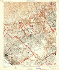
~ Sawtelle CA topo map, 1:24000 scale, 7.5 X 7.5 Minute, Historical, 1934
Sawtelle, California, USGS topographic map dated 1934.
Includes geographic coordinates (latitude and longitude). This topographic map is suitable for hiking, camping, and exploring, or framing it as a wall map.
Printed on-demand using high resolution imagery, on heavy weight and acid free paper, or alternatively on a variety of synthetic materials.
Topos available on paper, Waterproof, Poly, or Tyvek. Usually shipping rolled, unless combined with other folded maps in one order.
- Product Number: USGS-5657977
- Free digital map download (high-resolution, GeoPDF): Sawtelle, California (file size: 12 MB)
- Map Size: please refer to the dimensions of the GeoPDF map above
- Weight (paper map): ca. 55 grams
- Map Type: POD USGS Topographic Map
- Map Series: HTMC
- Map Verison: Historical
- Cell ID: 395921
- Scan ID: 300365
- Visual Version Number: 2
- Survey Year: 1923
- Datum: NAD
- Map Projection: Polyconic
- Map published by United States Geological Survey
- Map Language: English
- Scanner Resolution: 600 dpi
- Map Cell Name: Sawtelle
- Grid size: 7.5 X 7.5 Minute
- Date on map: 1934
- Map Scale: 1:24000
- Geographical region: California, United States
Neighboring Maps:
All neighboring USGS topo maps are available for sale online at a variety of scales.
Spatial coverage:
Topo map Sawtelle, California, covers the geographical area associated the following places:
- Westgate Heights - Santa Monica - Brentwood Heights - Beverly Hills - Sawtelle - Home Junction - Mar Vista - Century City - Palms - Brentwood Park - West Los Angeles - Ocean Park - Brentwood - Westwood Village - Westgate - Bel Air - Mar Vista Houses - Westwood
- Map Area ID: AREA34.134-118.5-118.4
- Northwest corner Lat/Long code: USGSNW34.1-118.5
- Northeast corner Lat/Long code: USGSNE34.1-118.4
- Southwest corner Lat/Long code: USGSSW34-118.5
- Southeast corner Lat/Long code: USGSSE34-118.4
- Northern map edge Latitude: 34.1
- Southern map edge Latitude: 34
- Western map edge Longitude: -118.5
- Eastern map edge Longitude: -118.4


