
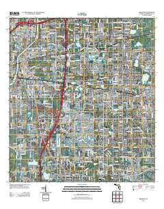
~ Brandon FL topo map, 1:24000 scale, 7.5 X 7.5 Minute, Historical, 2012
Brandon, Florida, USGS topographic map dated 2012.
Includes geographic coordinates (latitude and longitude). This topographic map is suitable for hiking, camping, and exploring, or framing it as a wall map.
Printed on-demand using high resolution imagery, on heavy weight and acid free paper, or alternatively on a variety of synthetic materials.
Topos available on paper, Waterproof, Poly, or Tyvek. Usually shipping rolled, unless combined with other folded maps in one order.
- Product Number: USGS-5655680
- Free digital map download (high-resolution, GeoPDF): Brandon, Florida (file size: 26 MB)
- Map Size: please refer to the dimensions of the GeoPDF map above
- Weight (paper map): ca. 55 grams
- Map Type: POD USGS Topographic Map
- Map Series: US Topo
- Map Verison: Historical
- Cell ID: 5263
- Datum: North American Datum of 1983
- Map Projection: Transverse Mercator
- Map Cell Name: Brandon
- Grid size: 7.5 X 7.5 Minute
- Date on map: 2012
- Map Scale: 1:24000
- Geographical region: Florida, United States
Neighboring Maps:
All neighboring USGS topo maps are available for sale online at a variety of scales.
Spatial coverage:
Topo map Brandon, Florida, covers the geographical area associated the following places:
- Oak Mont Woods - Watermill at Providence Lakes - Murray Acres - Valrico Village - Valrico Oaks - Valrico Vista - Brandon Brook - Kings Forest - Causeway Manor - Woodland Acres - Bloomingdale Oaks - Oakwood Heights - Eastside Mobile Villa - South Tampa - Buffalo Avenue Farms - Kim Acres - South Ridge - Brandon Woodlands - Camelot - Random Oaks - Timber Pond - Chickasaw Meadows - Seffner Park - Valrico Woodland - Lynnhaven - Brandon Groves - Barrington Oaks East - Delaney Creek Estates - Villages of Bloomingdale - High Oaks Manor - Brandon Park - Camellia Court - Hollowtree - Orient Park - Highland Manor - Hunters Cove - Fernwood Terrace - Kingwood Park - Bloomingdale Villas - Hickory Woods - Four Winds Estates - Pine Grove Reserve - Faulkenburg Heights - Tampa Tourist Club - Bloomingdale Village - Bryant Terrace - Green Meadow Estates - Crestwood Estates - Varn Park - Buckingham Place - Royal Manor - Amys Acres - Hickory Lake Estates - Clayton - Lake Saint Charles - Perrywood - Oakbriar - Brandon Tradewinds - Brandon Ridge - Wildwood Hollow - Broadway Heights East - Clifton Gardens - Timber Knoll - Fields Park Place - Faith Park - Shadow Bay - Boulevard Villas - Bloomingdale Trails - Knifke Estates - Lake Shore Ranch - Cien Fuegos - Pavilion Phase 3 - Abbey Trace - Eden Wood - Keebler - Seffner Heights - Southwood Hills - Alafia Estates - Hali Acres - Greenewood - Carriage Crossing - Buckhorn Springs Manor - Ponderosa - Happy Acres - Rolling Acres - Dixons - Meadow Woods Reserve - Quintessa - Sixmile Creek - Brandon View Estates - Pine Landing Villas - Stratford - East Gate Mobile Estates - Candlewood - Bloomingdale Ridge - Speedway Park - Parsons Reserve - Timber Creek - The Crescent - Loral
- Map Area ID: AREA2827.875-82.375-82.25
- Northwest corner Lat/Long code: USGSNW28-82.375
- Northeast corner Lat/Long code: USGSNE28-82.25
- Southwest corner Lat/Long code: USGSSW27.875-82.375
- Southeast corner Lat/Long code: USGSSE27.875-82.25
- Northern map edge Latitude: 28
- Southern map edge Latitude: 27.875
- Western map edge Longitude: -82.375
- Eastern map edge Longitude: -82.25


