
~ Naguabo PR topo map, 1:30000 scale, 7.5 X 7.5 Minute, Historical, 1946
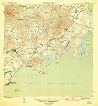
Naguabo, Puerto Rico, USGS topographic map dated 1946.
Includes geographic coordinates (latitude and longitude). This topographic map is suitable for hiking, camping, and exploring, or framing it as a wall map.
Printed on-demand using high resolution imagery, on heavy weight and acid free paper, or alternatively on a variety of synthetic materials.
Topos available on paper, Waterproof, Poly, or Tyvek. Usually shipping rolled, unless combined with other folded maps in one order.
- Product Number: USGS-5655394
- Free digital map download (high-resolution, GeoPDF): Naguabo, Puerto Rico (file size: 8 MB)
- Map Size: please refer to the dimensions of the GeoPDF map above
- Weight (paper map): ca. 55 grams
- Map Type: POD USGS Topographic Map
- Map Series: HTMC
- Map Verison: Historical
- Cell ID: 31273
- Scan ID: 362487
- Visual Version Number: 1
- Datum: Puerto Rico
- Map Projection: Polyconic
- Map published by United States Geological Survey
- Map Language: English
- Scanner Resolution: 600 dpi
- Map Cell Name: Naguabo
- Grid size: 7.5 X 7.5 Minute
- Date on map: 1946
- Map Scale: 1:30000
- Geographical region: Puerto Rico, United States
Neighboring Maps:
All neighboring USGS topo maps are available for sale online at a variety of scales.
Spatial coverage:
Topo map Naguabo, Puerto Rico, covers the geographical area associated the following places:
- Estación Botija - Villa del Pilar - Santa María - Estación Naguabo - Parcelas Machos - Alturas de Adjuntas - Brisas de Ceiba I - San Luis - Duque Comunidad - Aguas Claras - Naguabo Valley - Limones - Esperanza - Mariana - Las Vegas - Mendoza - Santiago y Lima - Naguabo Zona Urbana - Barrio Limones - Aguas Claras Comunidad - El Banco - Barriada Buenos Aires - Oriente (historical) - Celina - Brisas de Cieba - Villa Penetro - Naguabo - Residencial Jardines de Ceiba - Hacienda Grande - Húcares - Extension Santa Maria - Quebrada Seca - Playa de Naguabo - Jardin Esperanza - Punta Santiago - Jardines de Ceiba II - Residencial La Ceiba - Jardines de Ceiba I - Ceiba Zona Urbana - San Cristóbal - Tablones - Daguao - Villa Avila - Playa de Humacao - Villa del Rosario - Campamento Punta Lima - Ceiba - Daguao Comunidad - Suromar - Lomas Del Triunfo - Shanghai - Reparto Santiago - Residencial Mundo Plaza - Villa Flores - Los Hucares
- Map Area ID: AREA18.27518.15-65.75-65.625
- Northwest corner Lat/Long code: USGSNW18.275-65.75
- Northeast corner Lat/Long code: USGSNE18.275-65.625
- Southwest corner Lat/Long code: USGSSW18.15-65.75
- Southeast corner Lat/Long code: USGSSE18.15-65.625
- Northern map edge Latitude: 18.275
- Southern map edge Latitude: 18.15
- Western map edge Longitude: -65.75
- Eastern map edge Longitude: -65.625


