
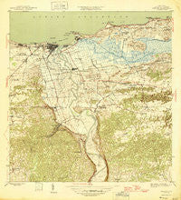
~ Arecibo PR topo map, 1:30000 scale, 7.5 X 7.5 Minute, Historical, 1946
Arecibo, Puerto Rico, USGS topographic map dated 1946.
Includes geographic coordinates (latitude and longitude). This topographic map is suitable for hiking, camping, and exploring, or framing it as a wall map.
Printed on-demand using high resolution imagery, on heavy weight and acid free paper, or alternatively on a variety of synthetic materials.
Topos available on paper, Waterproof, Poly, or Tyvek. Usually shipping rolled, unless combined with other folded maps in one order.
- Product Number: USGS-5655126
- Free digital map download (high-resolution, GeoPDF): Arecibo, Puerto Rico (file size: 9 MB)
- Map Size: please refer to the dimensions of the GeoPDF map above
- Weight (paper map): ca. 55 grams
- Map Type: POD USGS Topographic Map
- Map Series: HTMC
- Map Verison: Historical
- Cell ID: 1379
- Scan ID: 362327
- Woodland Tint: Yes
- Datum: Puerto Rico
- Map Projection: Polyconic
- Map published by United States Geological Survey
- Map Language: English
- Scanner Resolution: 600 dpi
- Map Cell Name: Arecibo
- Grid size: 7.5 X 7.5 Minute
- Date on map: 1946
- Map Scale: 1:30000
- Geographical region: Puerto Rico, United States
Neighboring Maps:
All neighboring USGS topo maps are available for sale online at a variety of scales.
Spatial coverage:
Topo map Arecibo, Puerto Rico, covers the geographical area associated the following places:
- Las Mercedes - Monte Rey - Boulevardo Buenos Aires - Cercadillo - Monte Grande - Oceanview - Higuillales - Garcia - Bajadero Comunidad - La Marina - Santana - Las Cántaras - Arecibo - Las Claras - Vista Mar - Extension Marquez - Obrero - Santa Bárbara - Domingo Ruíz - San Luis - Palo Blanco - Varela - San Lorenzo - El Coto - San Pedro - La Esperanza - Dominguito - Arecibo Gardens - Ballajá - San Francisco - Jarealito - Residencial Doctoro Zeno Gandia - Victor Rojas Number 1 - Marquez - Buena Vista - Las Llanadas - Animas - Los Coléricas - San Luis - Marteli - Biáfara - El Dique - Bajadero - La Guinea - Animas Comunidad - Charco Hondo - Oriente - Factor - Nola - Bella Vista - Miraflores - Villa Los Santos - Joya de los Santos - Arecibo Zona Urbana - El Espino - Hato Abajo - Central Los Caños
- Map Area ID: AREA18.518.375-66.75-66.625
- Northwest corner Lat/Long code: USGSNW18.5-66.75
- Northeast corner Lat/Long code: USGSNE18.5-66.625
- Southwest corner Lat/Long code: USGSSW18.375-66.75
- Southeast corner Lat/Long code: USGSSE18.375-66.625
- Northern map edge Latitude: 18.5
- Southern map edge Latitude: 18.375
- Western map edge Longitude: -66.75
- Eastern map edge Longitude: -66.625


