
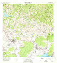
~ Yauco PR topo map, 1:20000 scale, 7.5 X 7.5 Minute, Historical, 1966, updated 1968
Yauco, Puerto Rico, USGS topographic map dated 1966.
Includes geographic coordinates (latitude and longitude). This topographic map is suitable for hiking, camping, and exploring, or framing it as a wall map.
Printed on-demand using high resolution imagery, on heavy weight and acid free paper, or alternatively on a variety of synthetic materials.
Topos available on paper, Waterproof, Poly, or Tyvek. Usually shipping rolled, unless combined with other folded maps in one order.
- Product Number: USGS-5655082
- Free digital map download (high-resolution, GeoPDF): Yauco, Puerto Rico (file size: 20 MB)
- Map Size: please refer to the dimensions of the GeoPDF map above
- Weight (paper map): ca. 55 grams
- Map Type: POD USGS Topographic Map
- Map Series: HTMC
- Map Verison: Historical
- Cell ID: 50056
- Scan ID: 362295
- Imprint Year: 1968
- Woodland Tint: Yes
- Aerial Photo Year: 1941
- Edit Year: 1966
- Field Check Year: 1943
- Datum: Puerto Rico
- Map Projection: Polyconic
- Map published by United States Geological Survey
- Map Language: English
- Scanner Resolution: 600 dpi
- Map Cell Name: Yauco
- Grid size: 7.5 X 7.5 Minute
- Date on map: 1966
- Map Scale: 1:20000
- Geographical region: Puerto Rico, United States
Neighboring Maps:
All neighboring USGS topo maps are available for sale online at a variety of scales.
Spatial coverage:
Topo map Yauco, Puerto Rico, covers the geographical area associated the following places:
- El Rosario - Cambalache - Guayanilla Zona Urbana - Hacienda Gloria - Residencial Padre Nazario - Lucchetti - Villa Milagros - Extension Santa Elena Del Monte III - Hacienda Florida - Santo Domingo - El Faro - Hacienda Catalina - Yauco Zona Urbana - San Agusto - Hacienda Fernández Rosal - Los Indios - Playa de Guayanilla - Santa Elena - La Quinta - Bahia Guayanilla 2 - Guayanilla - Almácigo Bajo - Hacienda Chesari - Poblado Sitios - La Capital - Magas Arriba Comunidad - Magas Abajo - Limas - Hacienda Pietri - Macaná - Magas Arriba - Arturo Lluberas - Hacienda Mejias - Villa del Rio - Piedras Blancas - Palomas - Palomas Comunidad - La Joya - Jardines de Borinquen - Hacienda Loyola - Sesctor Beldum - Extension Santa Elena De Monte II - Guaydía - Hacienda Vicario - Santa Maria - Reparto La Esperanza - Hacienda Mogote - Hacienda Pintado - Hacienda Roig - Hacienda Belgodere - Yauco - Villa Olimpia - Hospital Bella Vista - Barinas
- Map Area ID: AREA18.12518-66.875-66.75
- Northwest corner Lat/Long code: USGSNW18.125-66.875
- Northeast corner Lat/Long code: USGSNE18.125-66.75
- Southwest corner Lat/Long code: USGSSW18-66.875
- Southeast corner Lat/Long code: USGSSE18-66.75
- Northern map edge Latitude: 18.125
- Southern map edge Latitude: 18
- Western map edge Longitude: -66.875
- Eastern map edge Longitude: -66.75


