
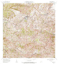
~ Corozal PR topo map, 1:20000 scale, 7.5 X 7.5 Minute, Historical, 1972, updated 1974
Corozal, Puerto Rico, USGS topographic map dated 1972.
Includes geographic coordinates (latitude and longitude). This topographic map is suitable for hiking, camping, and exploring, or framing it as a wall map.
Printed on-demand using high resolution imagery, on heavy weight and acid free paper, or alternatively on a variety of synthetic materials.
Topos available on paper, Waterproof, Poly, or Tyvek. Usually shipping rolled, unless combined with other folded maps in one order.
- Product Number: USGS-5654716
- Free digital map download (high-resolution, GeoPDF): Corozal, Puerto Rico (file size: 28 MB)
- Map Size: please refer to the dimensions of the GeoPDF map above
- Weight (paper map): ca. 55 grams
- Map Type: POD USGS Topographic Map
- Map Series: HTMC
- Map Verison: Historical
- Cell ID: 10181
- Scan ID: 362102
- Imprint Year: 1974
- Woodland Tint: Yes
- Visual Version Number: 1
- Aerial Photo Year: 1968
- Field Check Year: 1972
- Datum: Puerto Rico
- Map Projection: Polyconic
- Map published by United States Geological Survey
- Map Language: English
- Scanner Resolution: 600 dpi
- Map Cell Name: Corozal
- Grid size: 7.5 X 7.5 Minute
- Date on map: 1972
- Map Scale: 1:20000
- Geographical region: Puerto Rico, United States
Neighboring Maps:
All neighboring USGS topo maps are available for sale online at a variety of scales.
Spatial coverage:
Topo map Corozal, Puerto Rico, covers the geographical area associated the following places:
- Galateo - Padilla - Galateo Comunidad - El Centro - Alturas de Cibuco - Silvia - Berio - H. Rivera Colón Comunidad - H. Rivera Colon - Rivera y Lomas - La Aldea - Sobrino - Ortíz - Ramón Pabón - Corozal - Corozal Zona Urbana - Palmarejo - Medina - San Feliz - Extension Alturas de Cibuco - Loma Linda
- Map Area ID: AREA18.37518.25-66.375-66.25
- Northwest corner Lat/Long code: USGSNW18.375-66.375
- Northeast corner Lat/Long code: USGSNE18.375-66.25
- Southwest corner Lat/Long code: USGSSW18.25-66.375
- Southeast corner Lat/Long code: USGSSE18.25-66.25
- Northern map edge Latitude: 18.375
- Southern map edge Latitude: 18.25
- Western map edge Longitude: -66.375
- Eastern map edge Longitude: -66.25


