
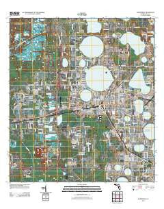
~ Auburndale FL topo map, 1:24000 scale, 7.5 X 7.5 Minute, Historical, 2012
Auburndale, Florida, USGS topographic map dated 2012.
Includes geographic coordinates (latitude and longitude). This topographic map is suitable for hiking, camping, and exploring, or framing it as a wall map.
Printed on-demand using high resolution imagery, on heavy weight and acid free paper, or alternatively on a variety of synthetic materials.
Topos available on paper, Waterproof, Poly, or Tyvek. Usually shipping rolled, unless combined with other folded maps in one order.
- Product Number: USGS-5652752
- Free digital map download (high-resolution, GeoPDF): Auburndale, Florida (file size: 22 MB)
- Map Size: please refer to the dimensions of the GeoPDF map above
- Weight (paper map): ca. 55 grams
- Map Type: POD USGS Topographic Map
- Map Series: US Topo
- Map Verison: Historical
- Cell ID: 1835
- Datum: North American Datum of 1983
- Map Projection: Transverse Mercator
- Map Cell Name: Auburndale
- Grid size: 7.5 X 7.5 Minute
- Date on map: 2012
- Map Scale: 1:24000
- Geographical region: Florida, United States
Neighboring Maps:
All neighboring USGS topo maps are available for sale online at a variety of scales.
Spatial coverage:
Topo map Auburndale, Florida, covers the geographical area associated the following places:
- Kris Mobile Home Park - Jerico Mobile Home Park - Pinewood Lane Mobile Home Park - Lake Blue Mobile Home Park - Jones Corner - Twin Oaks Mobile Home Park - Jan-Phyl Village - Lake Deer Mobile Hamlet - Ariana Shores Mobile Home Park - Palms Mobile Home Park - Fussells Corner - Tower Manor Mobile Home Community - Eagle Trailer Park - Bluemoon Mobile Home Park - Cypress Shores West Mobile Home Park - Inwood - Wagon Wheel Park Mobile Home Park - Carters Corner - Lake Dale Mobile Home Park - Lake Haven Mobile Home Park - Leisure Homes Mobile Park - Schalamar Creek Golf Country Club Community - Bide A While Mobile Home Park - Evergreen Mobile Home Estates - Shipp Reck Harbor Mobile Home Park - Dawson Mobile Home Park - J L Sweat Estates Mobile Home Park - Kossuthville - Happy Day Trailer Park - Lynchburg - Tropical Moon Mobile Home Park - Auburndale - Westside Ridge Mobile Home Community - Fussels Corner
- Map Area ID: AREA28.12528-81.875-81.75
- Northwest corner Lat/Long code: USGSNW28.125-81.875
- Northeast corner Lat/Long code: USGSNE28.125-81.75
- Southwest corner Lat/Long code: USGSSW28-81.875
- Southeast corner Lat/Long code: USGSSE28-81.75
- Northern map edge Latitude: 28.125
- Southern map edge Latitude: 28
- Western map edge Longitude: -81.875
- Eastern map edge Longitude: -81.75


