
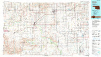
~ Elk City OK topo map, 1:100000 scale, 30 X 60 Minute, Historical, 1985, updated 1990
Elk City, Oklahoma, USGS topographic map dated 1985.
Includes geographic coordinates (latitude and longitude). This topographic map is suitable for hiking, camping, and exploring, or framing it as a wall map.
Printed on-demand using high resolution imagery, on heavy weight and acid free paper, or alternatively on a variety of synthetic materials.
Topos available on paper, Waterproof, Poly, or Tyvek. Usually shipping rolled, unless combined with other folded maps in one order.
- Product Number: USGS-5648507
- Free digital map download (high-resolution, GeoPDF): Elk City, Oklahoma (file size: 20 MB)
- Map Size: please refer to the dimensions of the GeoPDF map above
- Weight (paper map): ca. 55 grams
- Map Type: POD USGS Topographic Map
- Map Series: HTMC
- Map Verison: Historical
- Cell ID: 67470
- Scan ID: 707141
- Imprint Year: 1990
- Woodland Tint: Yes
- Aerial Photo Year: 1983
- Edit Year: 1985
- Datum: NAD27
- Map Projection: Universal Transverse Mercator
- Map published by United States Geological Survey
- Map Language: English
- Scanner Resolution: 508 dpi
- Map Cell Name: Elk City
- Grid size: 30 X 60 Minute
- Date on map: 1985
- Map Scale: 1:100000
- Geographical region: Oklahoma, United States
Neighboring Maps:
All neighboring USGS topo maps are available for sale online at a variety of scales.
Spatial coverage:
Topo map Elk City, Oklahoma, covers the geographical area associated the following places:
- Canute - Parkersburg - Carter - Berlin - Port - Grimes - Sentinel - Rocky - Jester - Taylor - Old Retrop - Retrop - Doxey - Willow - Delhi - Burns Flat - New Liberty - Elk City - Meridian - Lake Creek - Dill City - Cambridge - Plainview - Prentiss - Erick - Hext - Merritt - Foss - Hobart - Braithwaite - Bloomington - Mayfield - Hocker - Moravia - Sweetwater - Sayre - Brinkman - Texola
- Map Area ID: AREA35.535-100-99
- Northwest corner Lat/Long code: USGSNW35.5-100
- Northeast corner Lat/Long code: USGSNE35.5-99
- Southwest corner Lat/Long code: USGSSW35-100
- Southeast corner Lat/Long code: USGSSE35-99
- Northern map edge Latitude: 35.5
- Southern map edge Latitude: 35
- Western map edge Longitude: -100
- Eastern map edge Longitude: -99


