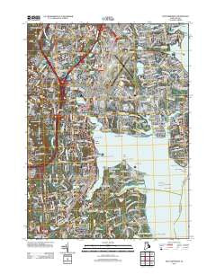
~ East Greenwich RI topo map, 1:24000 scale, 7.5 X 7.5 Minute, Historical, 2012
East Greenwich, Rhode Island, USGS topographic map dated 2012.
Includes geographic coordinates (latitude and longitude). This topographic map is suitable for hiking, camping, and exploring, or framing it as a wall map.
Printed on-demand using high resolution imagery, on heavy weight and acid free paper, or alternatively on a variety of synthetic materials.
Topos available on paper, Waterproof, Poly, or Tyvek. Usually shipping rolled, unless combined with other folded maps in one order.
- Product Number: USGS-5644904
- Free digital map download (high-resolution, GeoPDF): East Greenwich, Rhode Island (file size: 22 MB)
- Map Size: please refer to the dimensions of the GeoPDF map above
- Weight (paper map): ca. 55 grams
- Map Type: POD USGS Topographic Map
- Map Series: US Topo
- Map Verison: Historical
- Cell ID: 13374
- Datum: North American Datum of 1983
- Map Projection: Transverse Mercator
- Map Cell Name: East Greenwich
- Grid size: 7.5 X 7.5 Minute
- Date on map: 2012
- Map Scale: 1:24000
- Geographical region: Rhode Island, United States
Neighboring Maps:
All neighboring USGS topo maps are available for sale online at a variety of scales.
Spatial coverage:
Topo map East Greenwich, Rhode Island, covers the geographical area associated the following places:
- Cowesett - Old Warwick - Hillsgrove - Lincoln Park - Shawomet - Apponaug - Natick - Westcott - Hoxsie - Mount View - Spring Green - Palace Garden - Meadow View - Crossways (historical) - Bartons Corner - East Greenwich - Buttonwoods - Conimicut - Folly Landing - Potowomut - Oakland Beach - Frys Corner - Nausauket - Greenwood - Bayside - Wildes Corner - Frenchtown - Nichols Corner - Chepiwanoxet - Warwick - North Quidnessett - Howard - Old Buttonwoods - Thatch Cove (historical) - Quidnessett - Pontiac - Coles - East Natick - Kettle Corner - Lockwood Corner
- Map Area ID: AREA41.7541.625-71.5-71.375
- Northwest corner Lat/Long code: USGSNW41.75-71.5
- Northeast corner Lat/Long code: USGSNE41.75-71.375
- Southwest corner Lat/Long code: USGSSW41.625-71.5
- Southeast corner Lat/Long code: USGSSE41.625-71.375
- Northern map edge Latitude: 41.75
- Southern map edge Latitude: 41.625
- Western map edge Longitude: -71.5
- Eastern map edge Longitude: -71.375