
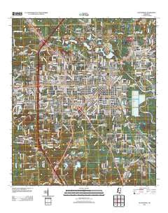
~ Hattiesburg MS topo map, 1:24000 scale, 7.5 X 7.5 Minute, Historical, 2012
Hattiesburg, Mississippi, USGS topographic map dated 2012.
Includes geographic coordinates (latitude and longitude). This topographic map is suitable for hiking, camping, and exploring, or framing it as a wall map.
Printed on-demand using high resolution imagery, on heavy weight and acid free paper, or alternatively on a variety of synthetic materials.
Topos available on paper, Waterproof, Poly, or Tyvek. Usually shipping rolled, unless combined with other folded maps in one order.
- Product Number: USGS-5640142
- Free digital map download (high-resolution, GeoPDF): Hattiesburg, Mississippi (file size: 27 MB)
- Map Size: please refer to the dimensions of the GeoPDF map above
- Weight (paper map): ca. 55 grams
- Map Type: POD USGS Topographic Map
- Map Series: US Topo
- Map Verison: Historical
- Cell ID: 19655
- Datum: North American Datum of 1983
- Map Projection: Transverse Mercator
- Map Cell Name: Hattiesburg
- Grid size: 7.5 X 7.5 Minute
- Date on map: 2012
- Map Scale: 1:24000
- Geographical region: Mississippi, United States
Neighboring Maps:
All neighboring USGS topo maps are available for sale online at a variety of scales.
Spatial coverage:
Topo map Hattiesburg, Mississippi, covers the geographical area associated the following places:
- Regency Estates - Petal - Kirkwood Park - Glendale - West Hills - Pot Likker Mobile Home Park - Lakewood - Woodlawn Court - Westover West - Lamar Park - Berkshire Hills - Bedford Woods West - Richburg - Hattiesburg - Innswood South - Forrest Garden Mobile Home Park - Westgate - Forrest Hills - Petal Mobile Home Park - Arnold Line - Westwood - Palmers Crossing - West Lake Manor - Bedford Woods - Varnado - Shadow Wood - Villa del Rey - Bonhomie - Heatherwood Estates - Woodhaven - Innswood - Sharon Acres - Tall Pines - Westover - Kensington Woods - Mars Hill - Riverside - Dixie Pine - Forrest Park - Harvey - Broadway Trailer Park - Richburg Heights
- Map Area ID: AREA31.37531.25-89.375-89.25
- Northwest corner Lat/Long code: USGSNW31.375-89.375
- Northeast corner Lat/Long code: USGSNE31.375-89.25
- Southwest corner Lat/Long code: USGSSW31.25-89.375
- Southeast corner Lat/Long code: USGSSE31.25-89.25
- Northern map edge Latitude: 31.375
- Southern map edge Latitude: 31.25
- Western map edge Longitude: -89.375
- Eastern map edge Longitude: -89.25


