
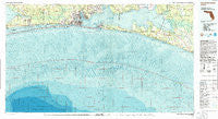
~ Fort Walton Beach FL topo map, 1:100000 scale, 30 X 60 Minute, Historical, 1978, updated 1986
Fort Walton Beach, Florida, USGS topographic map dated 1978.
Includes geographic coordinates (latitude and longitude). This topographic map is suitable for hiking, camping, and exploring, or framing it as a wall map.
Printed on-demand using high resolution imagery, on heavy weight and acid free paper, or alternatively on a variety of synthetic materials.
Topos available on paper, Waterproof, Poly, or Tyvek. Usually shipping rolled, unless combined with other folded maps in one order.
- Product Number: USGS-5637825
- Free digital map download (high-resolution, GeoPDF): Fort Walton Beach, Florida (file size: 41 MB)
- Map Size: please refer to the dimensions of the GeoPDF map above
- Weight (paper map): ca. 55 grams
- Map Type: POD USGS Topographic Map
- Map Series: HTMC
- Map Verison: Historical
- Cell ID: 67541
- Scan ID: 346324
- Imprint Year: 1986
- Woodland Tint: Yes
- Aerial Photo Year: 1976
- Edit Year: 1978
- Datum: NAD27
- Map Projection: Universal Transverse Mercator
- Map published by United States Geological Survey
- Map published by United States Department of Commerce
- Map Language: English
- Scanner Resolution: 600 dpi
- Map Cell Name: Fort Walton Beach
- Grid size: 30 X 60 Minute
- Date on map: 1978
- Map Scale: 1:100000
- Geographical region: Florida, United States
Neighboring Maps:
All neighboring USGS topo maps are available for sale online at a variety of scales.
Spatial coverage:
Topo map Fort Walton Beach, Florida, covers the geographical area associated the following places:
- Destin - Four Mile Village - Alys Beach - Muddy Ford - Turquoise Beach - Cinco Bayou - Choctaw Beach - Watercolor - Woodlawn Beach - Freeport - Point Washington - Seacrest - Choctaw Bay Estates - Garnier - Fort Walton Beach - Shalimar - Postil - Sandestin - Ocean City - Blue Gulf Beach - Wynnehaven Beach - Rosemary Beach - Inlet Beach - Harris - Blue Mountain Beach - Seagrove Beach - Choctaw - Tang-O-Mar Beach - Seascape - Grosh - La Grange Point - Old Bay View - Seaside - Mary Esther - Navarre - Villa Tasso - Harper - Gulf Pines - Dana Point - Beach Highlands - Fluffy Landing - Dune Allen Beach - Holley - Bay View - Dana Point - Big Hammock - Grayton Beach - Eglin Village - Santa Rosa Beach - Miramar Beach - Bunker - The Village of Baytowne Wharf - Seminole - Wright - Longwood - Lake Lorraine
- Map Area ID: AREA30.530-87-86
- Northwest corner Lat/Long code: USGSNW30.5-87
- Northeast corner Lat/Long code: USGSNE30.5-86
- Southwest corner Lat/Long code: USGSSW30-87
- Southeast corner Lat/Long code: USGSSE30-86
- Northern map edge Latitude: 30.5
- Southern map edge Latitude: 30
- Western map edge Longitude: -87
- Eastern map edge Longitude: -86


