
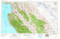
~ Santa Cruz CA topo map, 1:250000 scale, 1 X 2 Degree, Historical, 1958
Santa Cruz, California, USGS topographic map dated 1958.
Includes geographic coordinates (latitude and longitude). This topographic map is suitable for hiking, camping, and exploring, or framing it as a wall map.
Printed on-demand using high resolution imagery, on heavy weight and acid free paper, or alternatively on a variety of synthetic materials.
Topos available on paper, Waterproof, Poly, or Tyvek. Usually shipping rolled, unless combined with other folded maps in one order.
- Product Number: USGS-5637669
- Free digital map download (high-resolution, GeoPDF): Santa Cruz, California (file size: 21 MB)
- Map Size: please refer to the dimensions of the GeoPDF map above
- Weight (paper map): ca. 55 grams
- Map Type: POD USGS Topographic Map
- Map Series: HTMC
- Map Verison: Historical
- Cell ID: 74982
- Scan ID: 302145
- Woodland Tint: Yes
- Field Check Year: 1956
- Datum: Unstated
- Map Projection: Transverse Mercator
- Map published by United States Army Corps of Engineers
- Map published by United States Army
- Map Language: English
- Scanner Resolution: 600 dpi
- Map Cell Name: Monterey
- Grid size: 1 X 2 Degree
- Date on map: 1958
- Map Scale: 1:250000
- Geographical region: California, United States
Neighboring Maps:
All neighboring USGS topo maps are available for sale online at a variety of scales.
Spatial coverage:
Topo map Santa Cruz, California, covers the geographical area associated the following places:
- Ingle - Arbios - Tradewinds Mobile Home Park - La Vina - Tassajara Hot Springs - Capitola - Spreckels - Rancho Tierra Grande - Spreckels Junction - Old Gilroy - Carnadero - Paicines - Marina - Storey - Lucia - Biola - Interlaken - Creekside - Natividad - Sycamore Flat - Gordola - Giffen Cantua Ranch - San Juan Bautista - Cromir - Nashua - Panoche - Grove Mobile Home Park - Brookvale Terrace Mobile Home Park - Petroleum (historical) - Logan - Harlem - Johnston Corner - Rob Roy Junction - Betabel (historical) - Cabrillo Mobile Home Park - Tony Ziro Mobile Living Mobile Home Park - San Lucas - Westside - Old Hilltown - Jamesburg - Ellicott - Monterey Vista Mobile Home Park - Ambler Park - Soledad - Ocean Breeze Mobile Home Park - Dunneville - Fresno City (historical) - Santa Rita - Freedom - Monte Toyon - Aptos Hills - Orchard Lane Mobile Home Park - Watsonville Junction - Del Monte Heights - Ridgemark - San Ardo - Shangri La Estates - Oxalis - Sand City - La Selva Beach - Allegro Heights - Majors - New Brighton (historical) - Carmel Valley Manor - Tres Pinos - Aromas - Tranquillity - Seabright - Coburn - Bolsa Knolls - San Benito - Fort Romie - Dunbarton (historical) - Dean - Nares (historical) - Elsa - Pueblo de Figueroa (historical) - Hunter-Liggett - Rapetti (historical) - Hudner - Alisal - Moss Landing - Chualar - Soquel - Plantel (historical) - Nema (historical) - Italian Swiss Colony - Nuga (historical) - Meadows Manor Mobile Home Park - Chittenden - Salinas - Welby - Elkhorn - Five Points - Cannery Row - Cottage Corners - Calflax - Wood Ranch - Molus - Bitterwater
- Map Area ID: AREA3736-122.2-120
- Northwest corner Lat/Long code: USGSNW37-122.2
- Northeast corner Lat/Long code: USGSNE37-120
- Southwest corner Lat/Long code: USGSSW36-122.2
- Southeast corner Lat/Long code: USGSSE36-120
- Northern map edge Latitude: 37
- Southern map edge Latitude: 36
- Western map edge Longitude: -122.2
- Eastern map edge Longitude: -120


