
~ Harrison AR topo map, 1:100000 scale, 30 X 60 Minute, Historical, 1985, updated 1985
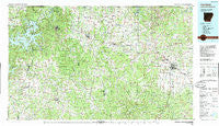
Harrison, Arkansas, USGS topographic map dated 1985.
Includes geographic coordinates (latitude and longitude). This topographic map is suitable for hiking, camping, and exploring, or framing it as a wall map.
Printed on-demand using high resolution imagery, on heavy weight and acid free paper, or alternatively on a variety of synthetic materials.
Topos available on paper, Waterproof, Poly, or Tyvek. Usually shipping rolled, unless combined with other folded maps in one order.
- Product Number: USGS-5637605
- Free digital map download (high-resolution, GeoPDF): Harrison, Arkansas (file size: 31 MB)
- Map Size: please refer to the dimensions of the GeoPDF map above
- Weight (paper map): ca. 55 grams
- Map Type: POD USGS Topographic Map
- Map Series: HTMC
- Map Verison: Historical
- Cell ID: 67640
- Scan ID: 260413
- Imprint Year: 1985
- Woodland Tint: Yes
- Aerial Photo Year: 1980
- Edit Year: 1985
- Datum: NAD27
- Map Projection: Universal Transverse Mercator
- Map published by United States Geological Survey
- Map Language: English
- Scanner Resolution: 600 dpi
- Map Cell Name: Harrison
- Grid size: 30 X 60 Minute
- Date on map: 1985
- Map Scale: 1:100000
- Geographical region: Arkansas, United States
Neighboring Maps:
All neighboring USGS topo maps are available for sale online at a variety of scales.
Spatial coverage:
Topo map Harrison, Arkansas, covers the geographical area associated the following places:
- Hill Top - Lowry - Winona Springs (historical) - Bland - New Hope - Loy - Purdy - Clantonville - Gateway - Tunnel (historical) - Plumlee (historical) - Grandview - Hopewell - Rivercliff Estates - Mayfield - Mundell (historical) - Maple - Crest - Tuttle - Huntsville - Vista Shores - Lick Branch - Yardelle - Green Acres - Little Arkansaw - Busch - Beaver - Burlington - Conner - Beechwood - Kingston - Garfield - Wolf Pen (historical) - Oakgrove - Goshen - Harrison - Cross Roads - Eureka Springs - Cottage Hill (historical) - New Town (historical) - Buckeye - Carrollton - Crumpler Subdivision - Urbanette - Cisco - High - Ponca - Ridgeway - Pine Top - Harmony - Coin - Walden (historical) - Pleasant Ridge - Allfriend (historical) - Oak Hill - Indian Creek (historical) - Wells Creek (historical) - Francis - Bear Creek Springs - Brasswell Spring (historical) - Wharton - Oregon (historical) - Lost Bridge Village - Jasper - Denver - Mount Sherman - Drakes Creek - Roxton - Rudd - Alpena - Old Alabam - Dean - Blue Eye - Marble - Cricket - Mount Pleasant (historical) - Junction (historical) - Pilgrims Rest - Wooden Hills - War Eagle Cove - Nunnally (historical) - Pleasant Valley - Osage - Hasty - Prosperity - Larue - Metalton - Shaver (historical) - Rambo Riviera - Capps - Walnut Hill - Mount Olive - Gaskins (historical) - Cave Spring (historical) - Watkins (historical) - Green Forest - Bergman - Hurd (historical) - Elmwood - Farewell
- Map Area ID: AREA36.536-94-93
- Northwest corner Lat/Long code: USGSNW36.5-94
- Northeast corner Lat/Long code: USGSNE36.5-93
- Southwest corner Lat/Long code: USGSSW36-94
- Southeast corner Lat/Long code: USGSSE36-93
- Northern map edge Latitude: 36.5
- Southern map edge Latitude: 36
- Western map edge Longitude: -94
- Eastern map edge Longitude: -93


