
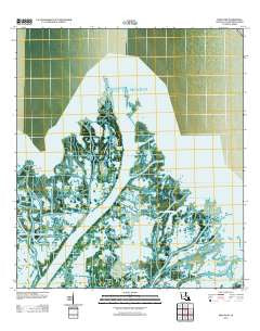
~ Main Pass LA topo map, 1:24000 scale, 7.5 X 7.5 Minute, Historical, 2012
Main Pass, Louisiana, USGS topographic map dated 2012.
Includes geographic coordinates (latitude and longitude). This topographic map is suitable for hiking, camping, and exploring, or framing it as a wall map.
Printed on-demand using high resolution imagery, on heavy weight and acid free paper, or alternatively on a variety of synthetic materials.
Topos available on paper, Waterproof, Poly, or Tyvek. Usually shipping rolled, unless combined with other folded maps in one order.
- Product Number: USGS-5637563
- Free digital map download (high-resolution, GeoPDF): Main Pass, Louisiana (file size: 19 MB)
- Map Size: please refer to the dimensions of the GeoPDF map above
- Weight (paper map): ca. 55 grams
- Map Type: POD USGS Topographic Map
- Map Series: US Topo
- Map Verison: Historical
- Cell ID: 27292
- Datum: North American Datum of 1983
- Map Projection: Transverse Mercator
- Map Cell Name: Main Pass
- Grid size: 7.5 X 7.5 Minute
- Date on map: 2012
- Map Scale: 1:24000
- Geographical region: Louisiana, United States
Neighboring Maps:
All neighboring USGS topo maps are available for sale online at a variety of scales.
Spatial coverage:
Topo map Main Pass, Louisiana, covers the geographical area associated the following places:
- Trespass Pond - Tessiers Bend - Snow Goose Bayou - Willow Outside Pond - Henderson Pond - Gauthier Pond - Redhead Outside Pond - Romere Pass Seaplane Base - Wiltz Pass - Stone Pond - Grants Pond - Scarabin Pond - Benedict Outside Pond - Scarabin Pass - Simeons Pond - Bienvenue Pass - Ronde Bayou - Contrariete Pass - Scarabin Island - Flatboat Bayou - Gaspar Island - Bell Pond - Potato Pond - Cottam Pass - Bennies Pond - Timber Bayou - Octave Pass - Dune Pond - Bills Pond - Ronde Pond - Harris Island - Blue Goose Pond - Battery Bayou - Bienvenue Outside Pond - Spoonbill Bend - Octave Pass North - Blackbird Pond - Lizzamonde Pond - Speckled Goose Pond - Cane Pond - Gaspar Inside Pond - Romere Pass - Romere Pass Oil and Gas Field - Piling Pond - Laurence Pond - Coon Outside Pond - East Fork - Grants Pass - Tonys Pond - Benedict Bayou - Bienvenue Inside Pond - Thomassin Pond - Christie Pond - Lake Pond - Timber Island - Delta Bend - Delta Pass - Widgeon Pond - Pintail Pond - Main Pass - Delta Cut - Gaspar Bayou - Japan Outside Pond - Joes Pond - Willow Bayou - Joes Outside Pond - Contrariete Island - Charlies Pass - Flatboat Pond - Bennies Pass - Gaspar Outside Pond
- Map Area ID: AREA29.37529.25-89.25-89.125
- Northwest corner Lat/Long code: USGSNW29.375-89.25
- Northeast corner Lat/Long code: USGSNE29.375-89.125
- Southwest corner Lat/Long code: USGSSW29.25-89.25
- Southeast corner Lat/Long code: USGSSE29.25-89.125
- Northern map edge Latitude: 29.375
- Southern map edge Latitude: 29.25
- Western map edge Longitude: -89.25
- Eastern map edge Longitude: -89.125


