
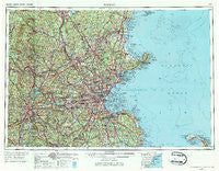
~ Boston MA topo map, 1:250000 scale, 1 X 2 Degree, Historical, 1956, updated 1984
Boston, Massachusetts, USGS topographic map dated 1956.
Includes geographic coordinates (latitude and longitude). This topographic map is suitable for hiking, camping, and exploring, or framing it as a wall map.
Printed on-demand using high resolution imagery, on heavy weight and acid free paper, or alternatively on a variety of synthetic materials.
Topos available on paper, Waterproof, Poly, or Tyvek. Usually shipping rolled, unless combined with other folded maps in one order.
- Product Number: USGS-5636177
- Free digital map download (high-resolution, GeoPDF): Boston, Massachusetts (file size: 28 MB)
- Map Size: please refer to the dimensions of the GeoPDF map above
- Weight (paper map): ca. 55 grams
- Map Type: POD USGS Topographic Map
- Map Series: HTMC
- Map Verison: Historical
- Cell ID: 68685
- Scan ID: 353235
- Imprint Year: 1984
- Woodland Tint: Yes
- Aerial Photo Year: 1952
- Edit Year: 1970
- Field Check Year: 1956
- Datum: Unstated
- Map Projection: Transverse Mercator
- Map published by United States Geological Survey
- Map published by: Military, Other
- Map Language: English
- Scanner Resolution: 600 dpi
- Map Cell Name: Boston
- Grid size: 1 X 2 Degree
- Date on map: 1956
- Map Scale: 1:250000
- Geographical region: Massachusetts, United States
Neighboring Maps:
All neighboring USGS topo maps are available for sale online at a variety of scales.
Spatial coverage:
Topo map Boston, Massachusetts, covers the geographical area associated the following places:
- Carlisle Station - Northbridge - Abington - Hampstead - Prospectville - Gloucester - Willows - Salem Neck - Windemere - Burlington - Princeton Village - Babson Park - Clematis Brook Station - Meadow Wood Trailer Park - Derry - Collettes Grove - Cummingsville - Mantyranta - Mattapan - Brockton Heights - Miramar - Mansfield - Shakerhill - Rocky Hill - Dunvegan Woods - East Pepperell - Crooks Corner - Middlesex Village - Nahant - South Peabody - Norwell Homes - Hayward Corner - Five Corners - Chandler Hill - Eliot - Millbrook - Bedford Springs - Waterford - Atkinson Heights - Charles River Grove - Westlands - Klondike Corner - Hamilton - Groveland - Reeds Ferry - Andover - Brentwood - Follen Heights - Oakland Vale - Four Corners - Brattle - South Milford - Purdy Corner - Hovey Corner - Rogersville (historical) - Riverside - Camp Ousamequin - Kent Park - Egypt - Devens - Tasseltop - Gates Crossing - Northville - Whidden Corner - Derry Village - Belmont Hill - Fennerville - North Acton - Baker Bridge - Squantum - Worcester - Curtis Corner - Camp Collier - South Duxbury - Kettle Cove Village - Lawrence Corner - Orchard Hills Estates - Pondville - Minot - Wilson - Symmes Corner - Marble Ridge Station - Bedford - Baileys Corner - Sharon Heights - New Worcester (historical) - Oak Hill - Five Corners - Kings Landing - Woonsocket - Nonantum - Foxvale - Crownridge Estates - Beaver Brook Station - Hancock - Pinefield - Lovell Corners - Brigadoon Village - Social - Natick
- Map Area ID: AREA4342-72-70
- Northwest corner Lat/Long code: USGSNW43-72
- Northeast corner Lat/Long code: USGSNE43-70
- Southwest corner Lat/Long code: USGSSW42-72
- Southeast corner Lat/Long code: USGSSE42-70
- Northern map edge Latitude: 43
- Southern map edge Latitude: 42
- Western map edge Longitude: -72
- Eastern map edge Longitude: -70


