
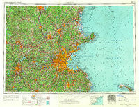
~ Boston MA topo map, 1:250000 scale, 1 X 2 Degree, Historical, 1956, updated 1967
Boston, Massachusetts, USGS topographic map dated 1956.
Includes geographic coordinates (latitude and longitude). This topographic map is suitable for hiking, camping, and exploring, or framing it as a wall map.
Printed on-demand using high resolution imagery, on heavy weight and acid free paper, or alternatively on a variety of synthetic materials.
Topos available on paper, Waterproof, Poly, or Tyvek. Usually shipping rolled, unless combined with other folded maps in one order.
- Product Number: USGS-5636169
- Free digital map download (high-resolution, GeoPDF): Boston, Massachusetts (file size: 20 MB)
- Map Size: please refer to the dimensions of the GeoPDF map above
- Weight (paper map): ca. 55 grams
- Map Type: POD USGS Topographic Map
- Map Series: HTMC
- Map Verison: Historical
- Cell ID: 68685
- Scan ID: 353231
- Imprint Year: 1967
- Woodland Tint: Yes
- Edit Year: 1966
- Field Check Year: 1956
- Datum: Unstated
- Map Projection: Transverse Mercator
- Map published by United States Army Corps of Engineers
- Map published by United States Army
- Map Language: English
- Scanner Resolution: 600 dpi
- Map Cell Name: Boston
- Grid size: 1 X 2 Degree
- Date on map: 1956
- Map Scale: 1:250000
- Geographical region: Massachusetts, United States
Neighboring Maps:
All neighboring USGS topo maps are available for sale online at a variety of scales.
Spatial coverage:
Topo map Boston, Massachusetts, covers the geographical area associated the following places:
- Hendersonville - Wilder - North Stoughton - Pepperell - North Londonderry - Tasseltop - Burrage - Southborough - Scituate Center - Malden Highlands - Needham Corner - East Derry - Shrewsbury Street - Arlington Park - Prospectville - Silver Lake - Oldham Pines - East Littleton - Jacobs Lake Shores - Maple Park - North Beverly - West Boxford - Mishawum - Halfway House - Norwell Homes - Cambridge - Camp Mary Day - Marblehead Neck - Lovell Corners - Collinsville - Merino Village (historical) - Windbrook Acres Mobile Home Park - Gibson Four Corners - Sheldonville - Post Island - West Parish - Wellesley Fells - Woonsocket - Happy Hills - New Boston - Oakland Square - Summit - Humarock - Mayflower Heights - East Douglas - Drury Square - Boston - North Danville - Auburn - Hodges Village - Felchville - East Arlington - Wachusett - South Quincy - Derry Village - New Village - West Leominster - Paxton - Saxonville - Winslow Estates - Marblehead - West Town Landing - Wethersfield - Holbrook - Medford - Jamaica Plain - East Bridgewater - Belmont Hill - North Chelmsford - North Pelham - Cominsville - Lanesville - Holliston - Melrose - West Andover - Turkey Hill Shores - West Medway - Chelmsford Center - Camp Barton - West Peabody - Mount Ida - Whitmanville - Littleton Common - Willows - East Dedham - Dawson - Country View Estates - Essex - Aqawam (historical) - Vose - Westborough - Unionville - Wadsworth - Hull - Leicester - Groton - Pinefield - East Cambridge - Manchester-by-the-Sea - Scituate Station
- Map Area ID: AREA4342-72-70
- Northwest corner Lat/Long code: USGSNW43-72
- Northeast corner Lat/Long code: USGSNE43-70
- Southwest corner Lat/Long code: USGSSW42-72
- Southeast corner Lat/Long code: USGSSE42-70
- Northern map edge Latitude: 43
- Southern map edge Latitude: 42
- Western map edge Longitude: -72
- Eastern map edge Longitude: -70


