
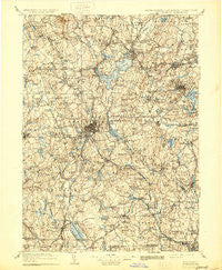
~ Quinsigamond MA topo map, 1:125000 scale, 30 X 30 Minute, Historical, 1908, updated 1930
Quinsigamond, Massachusetts, USGS topographic map dated 1908.
Includes geographic coordinates (latitude and longitude). This topographic map is suitable for hiking, camping, and exploring, or framing it as a wall map.
Printed on-demand using high resolution imagery, on heavy weight and acid free paper, or alternatively on a variety of synthetic materials.
Topos available on paper, Waterproof, Poly, or Tyvek. Usually shipping rolled, unless combined with other folded maps in one order.
- Product Number: USGS-5636157
- Free digital map download (high-resolution, GeoPDF): Quinsigamond, Massachusetts (file size: 11 MB)
- Map Size: please refer to the dimensions of the GeoPDF map above
- Weight (paper map): ca. 55 grams
- Map Type: POD USGS Topographic Map
- Map Series: HTMC
- Map Verison: Historical
- Cell ID: 66420
- Scan ID: 353216
- Imprint Year: 1930
- Survey Year: 1887
- Datum: Unstated
- Map Projection: Polyconic
- Map published by United States Geological Survey
- Map Language: English
- Scanner Resolution: 600 dpi
- Map Cell Name: Quinsicamond
- Grid size: 30 X 30 Minute
- Date on map: 1908
- Map Scale: 1:125000
- Geographical region: Massachusetts, United States
Neighboring Maps:
All neighboring USGS topo maps are available for sale online at a variety of scales.
Spatial coverage:
Topo map Quinsigamond, Massachusetts, covers the geographical area associated the following places:
- Ironstone - Salisbury Heights - Oxford - East Thompson - Manchaug - Five Corners - Morningdale - Hudson - Boylston Center - Belmont Hill - Morseville - Brittan Square - Great Brook Valley - Wheelockville - Westwood Hills - Shrewsbury Street - University Park - Gates Crossing - South Sutton - Moores Corners - Cordaville - Shrewsbury - Dorothy Manor - Camp Resolute - Island - Woodside - Sunnyside - Glen Grove - Rutland - East Berlin - Edgemere - West Oxford - South Bolton - Hopedale - Cominsville - Duck Harbor (historical) - North Woods - Chandler Hill - North Village - Douglas - Camp Bement - North Oxford - Hopkinton - Community Park - Hundred Acre Lot - Ebenville - Greendale - South Lancaster - Richardson Corners - New Worcester (historical) - Halfway House - College Hill - Merino Village - Grafton - Camp Neyati - Oakland Heights - Hamlet - Waterford - Pratt Junction - Cherry Valley - Grand View Estates - Southborough - Pleasant Valley - Muschopauge - Uxbridge - Webster Square - Windbrook Acres Mobile Home Park - Linwood - Charlton City - White Hall - Sterling Camp Grounds - West Auburn - Meadowbrook Mobile Home Park - Riverdale - Swan Avenue - Millbury Junction - West Upton - Worcester - South Grafton Street - Quinsigamond Village - Woonsocket - Boxboro - Perryville - Axtell Corner - Wawela Park - Sterling - Rochdale - Lancaster - North Village - Sterling Junction - Westborough - Spindleville - Quinapoxet - Colonial Park - Fennerville - Paxton - Sandy Beach - White City - Clinton - Turkey Hill Shores
- Map Area ID: AREA42.542-72-71.5
- Northwest corner Lat/Long code: USGSNW42.5-72
- Northeast corner Lat/Long code: USGSNE42.5-71.5
- Southwest corner Lat/Long code: USGSSW42-72
- Southeast corner Lat/Long code: USGSSE42-71.5
- Northern map edge Latitude: 42.5
- Southern map edge Latitude: 42
- Western map edge Longitude: -72
- Eastern map edge Longitude: -71.5


