
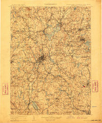
~ Quinsigamond MA topo map, 1:125000 scale, 30 X 30 Minute, Historical, 1908, updated 1910
Quinsigamond, Massachusetts, USGS topographic map dated 1908.
Includes geographic coordinates (latitude and longitude). This topographic map is suitable for hiking, camping, and exploring, or framing it as a wall map.
Printed on-demand using high resolution imagery, on heavy weight and acid free paper, or alternatively on a variety of synthetic materials.
Topos available on paper, Waterproof, Poly, or Tyvek. Usually shipping rolled, unless combined with other folded maps in one order.
- Product Number: USGS-5636155
- Free digital map download (high-resolution, GeoPDF): Quinsigamond, Massachusetts (file size: 11 MB)
- Map Size: please refer to the dimensions of the GeoPDF map above
- Weight (paper map): ca. 55 grams
- Map Type: POD USGS Topographic Map
- Map Series: HTMC
- Map Verison: Historical
- Cell ID: 66420
- Scan ID: 353210
- Imprint Year: 1910
- Survey Year: 1887
- Datum: Unstated
- Map Projection: Unstated
- Map published by United States Geological Survey
- Map Language: English
- Scanner Resolution: 600 dpi
- Map Cell Name: Quinsicamond
- Grid size: 30 X 30 Minute
- Date on map: 1908
- Map Scale: 1:125000
- Geographical region: Massachusetts, United States
Neighboring Maps:
All neighboring USGS topo maps are available for sale online at a variety of scales.
Spatial coverage:
Topo map Quinsigamond, Massachusetts, covers the geographical area associated the following places:
- Mill Street - West Rutland - Stoneville - Blackstone - Trowbridgeville (historical) - Halfway House - Spencer - Upton - Mendon - Woodland Park - Pratt Junction - New Worcester (historical) - South Sutton - Edgemere - Milford - Fryville - North Rutland - Sterling Junction - North Woods - Quinsigamond Village - West Millbury - Swan Avenue - West Sterling - Camp Green Eyrie - Union Hill - Sunnyside - Northville (historical) - Grand View Estates - Chandler Hill - Seventh Day Adventist Village - Glen Grove - Fayville - Social - Oakdale - Bloomingdale - Heard Street - Waterford - Browns Corner - Boylston - Wilkinsonville - West Upton - Sterling Camp Grounds - Millville - Marlborough - Sibleys Corner - Loveland - East Berlin - Princeton - Oxford Heights - Ludlow - South Grafton Street - Whitinsville - Tasseltop - Vernon Hill - West Tatnuck - Marions Camp - West Oxford - Cardinal Heights - Ruralville - Kittville - Douglas - Dodge - Dorothy Pond - North Village - East Millbury - Oakland Heights - Pleasant Valley - Ponakin Mill - Community Park - South Shrewsbury - Lambs Grove - Boylston Center - Proctors corner - North Oxford - Beverly Road - Dorothy Manor - Belmont Hill - West Boylston - Linwood - Dawson - Ironstone - Carterville - Wessonville - Tafts Corner - Sunderland - North Worcester - Muschopauge - Chaseville - East Blackstone - West Berlin - Shrewsbury - Woodside - Northside - Westchester - Webster Square - New Village - University Park - Meadowbrook Mobile Home Park - West Village - Camp Bement
- Map Area ID: AREA42.542-72-71.5
- Northwest corner Lat/Long code: USGSNW42.5-72
- Northeast corner Lat/Long code: USGSNE42.5-71.5
- Southwest corner Lat/Long code: USGSSW42-72
- Southeast corner Lat/Long code: USGSSE42-71.5
- Northern map edge Latitude: 42.5
- Southern map edge Latitude: 42
- Western map edge Longitude: -72
- Eastern map edge Longitude: -71.5


