
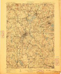
~ Quinsigamond MA topo map, 1:125000 scale, 30 X 30 Minute, Historical, 1908
Quinsigamond, Massachusetts, USGS topographic map dated 1908.
Includes geographic coordinates (latitude and longitude). This topographic map is suitable for hiking, camping, and exploring, or framing it as a wall map.
Printed on-demand using high resolution imagery, on heavy weight and acid free paper, or alternatively on a variety of synthetic materials.
Topos available on paper, Waterproof, Poly, or Tyvek. Usually shipping rolled, unless combined with other folded maps in one order.
- Product Number: USGS-5636153
- Free digital map download (high-resolution, GeoPDF): Quinsigamond, Massachusetts (file size: 11 MB)
- Map Size: please refer to the dimensions of the GeoPDF map above
- Weight (paper map): ca. 55 grams
- Map Type: POD USGS Topographic Map
- Map Series: HTMC
- Map Verison: Historical
- Cell ID: 66420
- Scan ID: 353208
- Survey Year: 1887
- Datum: Unstated
- Map Projection: Unstated
- Map published by United States Geological Survey
- Map Language: English
- Scanner Resolution: 600 dpi
- Map Cell Name: Quinsicamond
- Grid size: 30 X 30 Minute
- Date on map: 1908
- Map Scale: 1:125000
- Geographical region: Massachusetts, United States
Neighboring Maps:
All neighboring USGS topo maps are available for sale online at a variety of scales.
Spatial coverage:
Topo map Quinsigamond, Massachusetts, covers the geographical area associated the following places:
- Northbridge - Meadowbrook Mobile Home Park - Camp Green Eyrie - Ebenville - Swan Avenue - Sandy Beach - South Shrewsbury - Grafton - West Oxford - Fabyan - Northbridge Center - Texas - Chaseville - South Sutton - Colonial Park - Sterling Junction - Linwood - University Park - Slatersville - June Street - Woodland Park - Five Corners - Burncoat - Lower Wire Village - Cambridge - Rutland - Carterville - Princeton - Hudson - Fennerville - Webster - Wilkinsonville - Shrewsbury - Farnumsville - Community Park - Marlborough - Greenville - Boxboro - Belmont Hill - Oakdale - East Douglas - Orchard Hills Estates - North Grafton - Stow - South Grafton Street - Browns Corner - Salisbury Heights - Wilsonville - Cominsville - Massasoit - Westborough - Chapinville - Greendale - Pakachoag - Dorothy Pond - Mendon - College Hill - Tatnuck - South Charlton - Edgemere - Camp Barton - Ponakin Mill - Social - Boylston - Loveland - Plummer Corner - Heard Street - Millbury Junction - Trowbridgeville (historical) - Southborough - Cordaville - East Blackstone - West Auburn - North Worcester - Grand View Estates - Hopkinton - West Upton - Maplewood - Shrewsbury Street - Auburn - Hamilton - Old Common - Gleasondale Station - Windbrook Acres Mobile Home Park - Cherry Valley - Fullerville (historical) - Brockway Corner - Glen Heights - Whispering Pines Estates Mobile Home Park - Northville (historical) - Northside - East Sutton - Brooks - West Tatnuck - Northborough - Worcester - Waterford - Ironstone - Camp Virginia - Hundred Acre Lot
- Map Area ID: AREA42.542-72-71.5
- Northwest corner Lat/Long code: USGSNW42.5-72
- Northeast corner Lat/Long code: USGSNE42.5-71.5
- Southwest corner Lat/Long code: USGSSW42-72
- Southeast corner Lat/Long code: USGSSE42-71.5
- Northern map edge Latitude: 42.5
- Southern map edge Latitude: 42
- Western map edge Longitude: -72
- Eastern map edge Longitude: -71.5


