
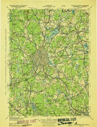
~ Quinsigamond MA topo map, 1:125000 scale, 30 X 30 Minute, Historical, 1943
Quinsigamond, Massachusetts, USGS topographic map dated 1943.
Includes geographic coordinates (latitude and longitude). This topographic map is suitable for hiking, camping, and exploring, or framing it as a wall map.
Printed on-demand using high resolution imagery, on heavy weight and acid free paper, or alternatively on a variety of synthetic materials.
Topos available on paper, Waterproof, Poly, or Tyvek. Usually shipping rolled, unless combined with other folded maps in one order.
- Product Number: USGS-5636151
- Free digital map download (high-resolution, GeoPDF): Quinsigamond, Massachusetts (file size: 9 MB)
- Map Size: please refer to the dimensions of the GeoPDF map above
- Weight (paper map): ca. 55 grams
- Map Type: POD USGS Topographic Map
- Map Series: HTMC
- Map Verison: Historical
- Cell ID: 66420
- Scan ID: 351248
- Woodland Tint: Yes
- Aerial Photo Year: 1938
- Datum: NAD27
- Map Projection: Polyconic
- Map published by United States Army Corps of Engineers
- Map published by United States Army
- Map published by United States Department of War
- Map Language: English
- Scanner Resolution: 600 dpi
- Map Cell Name: Quinsicamond
- Grid size: 30 X 30 Minute
- Date on map: 1943
- Map Scale: 1:125000
- Geographical region: Massachusetts, United States
Neighboring Maps:
All neighboring USGS topo maps are available for sale online at a variety of scales.
Spatial coverage:
Topo map Quinsigamond, Massachusetts, covers the geographical area associated the following places:
- Maplewood - White City - Sunnyside - Sterling - Old Common - Milford - Sunderland - West Berlin - West Millbury - Uxbridge - South Charlton - North Village - Cordaville - East Bolton - Woodville - Orchard Hills Estates - Millbury Junction - Colonial Park - Spencer - Gates Crossing - Woodland Park - Marlborough Junction - Webster Square - Ward Corner - Dorothy Manor - Waterford - Worcester - College Hill - North Worcester - Dawson - Camp Neyati - Chadwick Square - Chapinville - Seventh Day Adventist Village - Oxford Heights - Fullerville (historical) - Jefferson - Beaver Brook - West Upton - Grand View Estates - Northbridge - Edgemere - Upton - South Milford - Oxford - Fairlawn - Pratt Junction - Swan Avenue - Rochdale - Dorothy Pond - Morningdale - Morseville - Brooks - Holden Center - Merino Village - Massasoit - Sutton - Wilkinsonville - Wheelockville - Fisherville - Oak Hill - Hodges Village - Camp Bement - Quinsigamond Village - Halfway House - Union Hill - Prentice Corner - Northville (historical) - Burncoat - Slatersville - New Village - Northborough - Trowbridgeville (historical) - Gleasondale Station - Whitinsville - Sterling Junction - Millbury - New Boston - Axtell Corner - Oakland Heights - South Berlin - Brittan Square - Camp Virginia - West Sterling - Ponakin Mill - Manchaug - Canada Mills - Hamilton - Camp Kinneywood - Blackstone - Shrewsbury - East Douglas - Bramanville - University Park - Auburn - Dudley - Hopkinton - East Sutton - Chestnut Hill Meeting House - Jamesville (historical)
- Map Area ID: AREA42.542-72-71.5
- Northwest corner Lat/Long code: USGSNW42.5-72
- Northeast corner Lat/Long code: USGSNE42.5-71.5
- Southwest corner Lat/Long code: USGSSW42-72
- Southeast corner Lat/Long code: USGSSE42-71.5
- Northern map edge Latitude: 42.5
- Southern map edge Latitude: 42
- Western map edge Longitude: -72
- Eastern map edge Longitude: -71.5


